You are here: Home > Network List > UO - University of Oregon Regional Network Stations List
> Station VITI Monroe, OR, USA > Earthquake Result Viewer
VITI Monroe, OR, USA - Earthquake Result Viewer
| Earthquake location: |
Eastern New Guinea Reg., P.N.G. |
| Earthquake latitude/longitude: |
-7.8/147.8 |
| Earthquake time(UTC): |
2020/07/17 (199) 02:50:23 GMT |
| Earthquake Depth: |
85 km |
| Earthquake Magnitude: |
6.9 mww |
| Earthquake Catalog/Contributor: |
NEIC PDE/us |
|
| Network: |
UO University of Oregon Regional Network |
| Station: |
VITI Monroe, OR, USA |
| Lat/Lon: |
44.28 N/123.32 W |
| Elevation: |
258 m |
|
| Distance: |
94.6 deg |
| Az: |
46.096 deg |
| Baz: |
263.645 deg |
| Ray Param: |
0.040939417 |
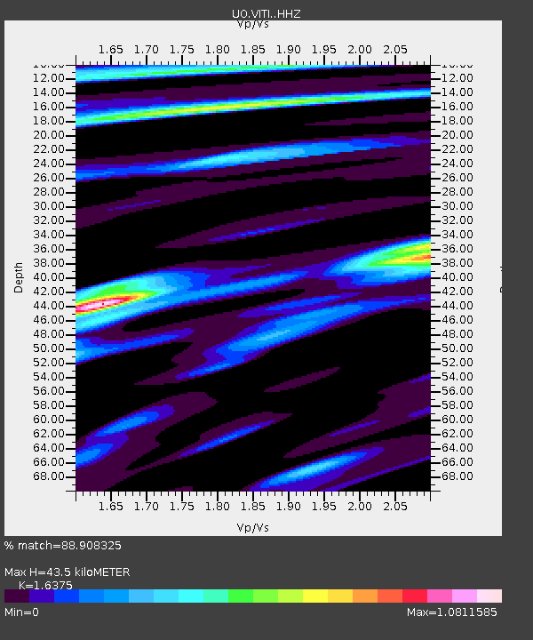
| Estimated Moho Depth: |
43.5 km |
| Estimated Crust Vp/Vs: |
1.64 |
| Assumed Crust Vp: |
6.566 km/s |
| Estimated Crust Vs: |
4.01 km/s |
| Estimated Crust Poisson's Ratio: |
0.20 |
|
| Radial Match: |
88.908325 % |
| Radial Bump: |
400 |
| Transverse Match: |
79.5603 % |
| Transverse Bump: |
400 |
| SOD ConfigId: |
21709731 |
| Insert Time: |
2020-07-31 03:10:05.660 +0000 |
| GWidth: |
2.5 |
| Max Bumps: |
400 |
| Tol: |
0.001 |
|

Signal To Noise
| Channel | StoN | STA | LTA |
| UO:VITI: :HHZ:20200717T03:03:03.520019Z | 7.9236364 | 2.102354E-6 | 2.6532692E-7 |
| UO:VITI: :HHN:20200717T03:03:03.520019Z | 1.701176 | 3.8982583E-7 | 2.2915079E-7 |
| UO:VITI: :HHE:20200717T03:03:03.520019Z | 3.005066 | 7.46529E-7 | 2.484235E-7 |
| Arrivals |
| Ps | 4.3 SECOND |
| PpPs | 17 SECOND |
| PsPs/PpSs | 21 SECOND |


