You are here: Home > Network List > UW - Pacific Northwest Regional Seismic Network Stations List
> Station DOSE Dosewallips old TA.C04A, WA > Earthquake Result Viewer
DOSE Dosewallips old TA.C04A, WA - Earthquake Result Viewer
| Earthquake location: |
Eastern New Guinea Reg., P.N.G. |
| Earthquake latitude/longitude: |
-7.8/147.8 |
| Earthquake time(UTC): |
2020/07/17 (199) 02:50:23 GMT |
| Earthquake Depth: |
85 km |
| Earthquake Magnitude: |
6.9 mww |
| Earthquake Catalog/Contributor: |
NEIC PDE/us |
|
| Network: |
UW Pacific Northwest Regional Seismic Network |
| Station: |
DOSE Dosewallips old TA.C04A, WA |
| Lat/Lon: |
47.72 N/122.97 W |
| Elevation: |
53 m |
|
| Distance: |
95.3 deg |
| Az: |
42.692 deg |
| Baz: |
264.187 deg |
| Ray Param: |
0.040783785 |
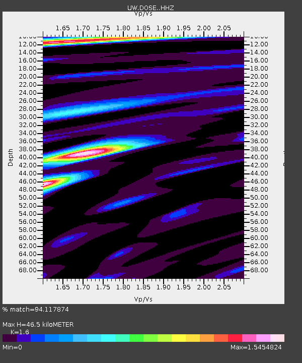
| Estimated Moho Depth: |
46.5 km |
| Estimated Crust Vp/Vs: |
1.60 |
| Assumed Crust Vp: |
6.566 km/s |
| Estimated Crust Vs: |
4.104 km/s |
| Estimated Crust Poisson's Ratio: |
0.18 |
|
| Radial Match: |
94.117874 % |
| Radial Bump: |
400 |
| Transverse Match: |
87.77044 % |
| Transverse Bump: |
400 |
| SOD ConfigId: |
21709731 |
| Insert Time: |
2020-07-31 03:10:39.634 +0000 |
| GWidth: |
2.5 |
| Max Bumps: |
400 |
| Tol: |
0.001 |
|

Signal To Noise
| Channel | StoN | STA | LTA |
| UW:DOSE: :HHZ:20200717T03:03:06.260009Z | 22.106892 | 1.58833E-6 | 7.184773E-8 |
| UW:DOSE: :HHN:20200717T03:03:06.260009Z | 3.981247 | 1.699245E-7 | 4.268123E-8 |
| UW:DOSE: :HHE:20200717T03:03:06.260009Z | 4.3455696 | 3.5793104E-7 | 8.2366896E-8 |
| Arrivals |
| Ps | 4.3 SECOND |
| PpPs | 18 SECOND |
| PsPs/PpSs | 22 SECOND |


