You are here: Home > Network List > UW - Pacific Northwest Regional Seismic Network Stations List
> Station HOOD Mt Hood Meadows, OR CREST BB SMO > Earthquake Result Viewer
HOOD Mt Hood Meadows, OR CREST BB SMO - Earthquake Result Viewer
| Earthquake location: |
Eastern New Guinea Reg., P.N.G. |
| Earthquake latitude/longitude: |
-7.8/147.8 |
| Earthquake time(UTC): |
2020/07/17 (199) 02:50:23 GMT |
| Earthquake Depth: |
85 km |
| Earthquake Magnitude: |
6.9 mww |
| Earthquake Catalog/Contributor: |
NEIC PDE/us |
|
| Network: |
UW Pacific Northwest Regional Seismic Network |
| Station: |
HOOD Mt Hood Meadows, OR CREST BB SMO |
| Lat/Lon: |
45.32 N/121.65 W |
| Elevation: |
1520 m |
|
| Distance: |
95.9 deg |
| Az: |
45.176 deg |
| Baz: |
264.899 deg |
| Ray Param: |
0.04059812 |
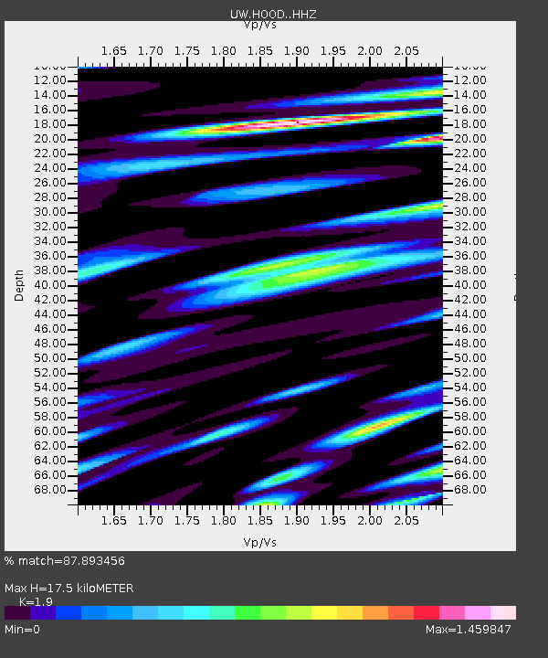
| Estimated Moho Depth: |
17.5 km |
| Estimated Crust Vp/Vs: |
1.90 |
| Assumed Crust Vp: |
6.597 km/s |
| Estimated Crust Vs: |
3.472 km/s |
| Estimated Crust Poisson's Ratio: |
0.31 |
|
| Radial Match: |
87.893456 % |
| Radial Bump: |
400 |
| Transverse Match: |
78.96867 % |
| Transverse Bump: |
400 |
| SOD ConfigId: |
21709731 |
| Insert Time: |
2020-07-31 03:10:51.975 +0000 |
| GWidth: |
2.5 |
| Max Bumps: |
400 |
| Tol: |
0.001 |
|

Signal To Noise
| Channel | StoN | STA | LTA |
| UW:HOOD: :HHZ:20200717T03:03:09.330016Z | 20.793919 | 1.71899E-6 | 8.2667924E-8 |
| UW:HOOD: :HHN:20200717T03:03:09.330016Z | 0.8667425 | 3.1490322E-7 | 3.6331807E-7 |
| UW:HOOD: :HHE:20200717T03:03:09.330016Z | 3.1822093 | 5.6302576E-7 | 1.7692922E-7 |
| Arrivals |
| Ps | 2.4 SECOND |
| PpPs | 7.5 SECOND |
| PsPs/PpSs | 10.0 SECOND |


