You are here: Home > Network List > UW - Pacific Northwest Regional Seismic Network Stations List
> Station WOLL Wollman Farm, Schrag, WA, USA > Earthquake Result Viewer
WOLL Wollman Farm, Schrag, WA, USA - Earthquake Result Viewer
| Earthquake location: |
Eastern New Guinea Reg., P.N.G. |
| Earthquake latitude/longitude: |
-7.8/147.8 |
| Earthquake time(UTC): |
2020/07/17 (199) 02:50:23 GMT |
| Earthquake Depth: |
85 km |
| Earthquake Magnitude: |
6.9 mww |
| Earthquake Catalog/Contributor: |
NEIC PDE/us |
|
| Network: |
UW Pacific Northwest Regional Seismic Network |
| Station: |
WOLL Wollman Farm, Schrag, WA, USA |
| Lat/Lon: |
47.06 N/118.92 W |
| Elevation: |
385 m |
|
| Distance: |
97.9 deg |
| Az: |
43.566 deg |
| Baz: |
267.059 deg |
| Ray Param: |
0.039989952 |
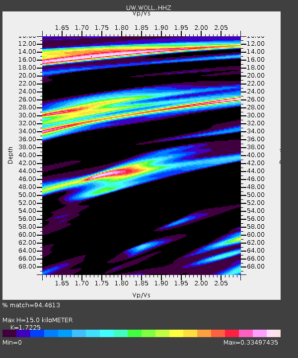
| Estimated Moho Depth: |
15.0 km |
| Estimated Crust Vp/Vs: |
1.72 |
| Assumed Crust Vp: |
6.419 km/s |
| Estimated Crust Vs: |
3.727 km/s |
| Estimated Crust Poisson's Ratio: |
0.25 |
|
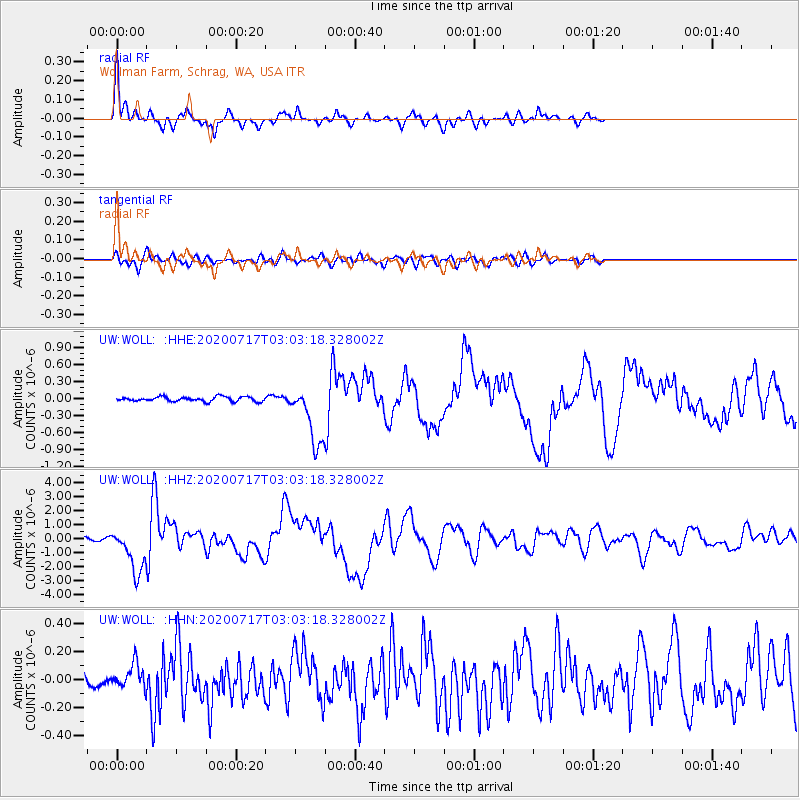
| Radial Match: |
94.4613 % |
| Radial Bump: |
362 |
| Transverse Match: |
78.951 % |
| Transverse Bump: |
400 |
| SOD ConfigId: |
21709731 |
| Insert Time: |
2020-07-31 03:11:50.592 +0000 |
| GWidth: |
2.5 |
| Max Bumps: |
400 |
| Tol: |
0.001 |
|
Signal To Noise
| Channel | StoN | STA | LTA |
| UW:WOLL: :HHZ:20200717T03:03:18.328002Z | 14.037773 | 1.5938666E-6 | 1.13541276E-7 |
| UW:WOLL: :HHN:20200717T03:03:18.328002Z | 1.2166171 | 8.465944E-8 | 6.9585944E-8 |
| UW:WOLL: :HHE:20200717T03:03:18.328002Z | 13.127237 | 5.257962E-7 | 4.0053838E-8 |
| Arrivals |
| Ps | 1.7 SECOND |
| PpPs | 6.2 SECOND |
| PsPs/PpSs | 8.0 SECOND |


