You are here: Home > Network List > YO16 - Yukon Observatory Stations List
> Station KOTA YGS, Kotaneelee Airstrip, YK > Earthquake Result Viewer
KOTA YGS, Kotaneelee Airstrip, YK - Earthquake Result Viewer
| Earthquake location: |
Eastern New Guinea Reg., P.N.G. |
| Earthquake latitude/longitude: |
-7.8/147.8 |
| Earthquake time(UTC): |
2020/07/17 (199) 02:50:23 GMT |
| Earthquake Depth: |
85 km |
| Earthquake Magnitude: |
6.9 mww |
| Earthquake Catalog/Contributor: |
NEIC PDE/us |
|
| Network: |
YO Yukon Observatory |
| Station: |
KOTA YGS, Kotaneelee Airstrip, YK |
| Lat/Lon: |
60.13 N/124.05 W |
| Elevation: |
386 m |
|
| Distance: |
95.8 deg |
| Az: |
30.193 deg |
| Baz: |
264.523 deg |
| Ray Param: |
0.040623438 |
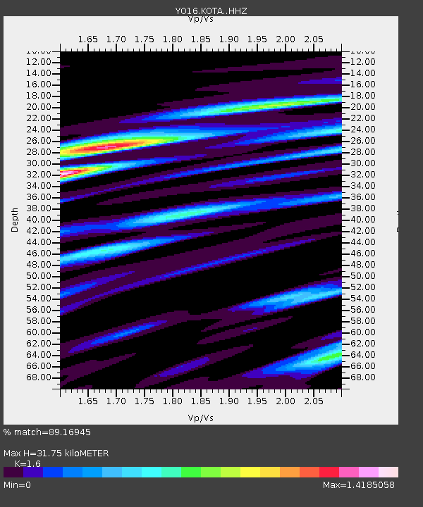
| Estimated Moho Depth: |
31.75 km |
| Estimated Crust Vp/Vs: |
1.60 |
| Assumed Crust Vp: |
6.419 km/s |
| Estimated Crust Vs: |
4.012 km/s |
| Estimated Crust Poisson's Ratio: |
0.18 |
|
| Radial Match: |
89.16945 % |
| Radial Bump: |
400 |
| Transverse Match: |
75.66675 % |
| Transverse Bump: |
400 |
| SOD ConfigId: |
21709731 |
| Insert Time: |
2020-07-31 03:12:13.543 +0000 |
| GWidth: |
2.5 |
| Max Bumps: |
400 |
| Tol: |
0.001 |
|

Signal To Noise
| Channel | StoN | STA | LTA |
| YO:KOTA: :HHZ:20200717T03:03:08.919982Z | 25.401178 | 2.231004E-6 | 8.783072E-8 |
| YO:KOTA: :HHN:20200717T03:03:08.919982Z | 1.733097 | 1.9173166E-7 | 1.1062951E-7 |
| YO:KOTA: :HHE:20200717T03:03:08.919982Z | 4.5307364 | 5.336518E-7 | 1.1778479E-7 |
| Arrivals |
| Ps | 3.0 SECOND |
| PpPs | 13 SECOND |
| PsPs/PpSs | 16 SECOND |


