You are here: Home > Network List > US - United States National Seismic Network Stations List
> Station MNTX Cornudas Mountains, Texas, USA > Earthquake Result Viewer
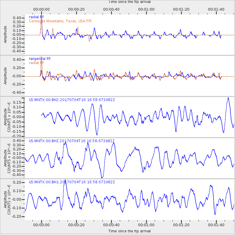
MNTX Cornudas Mountains, Texas, USA - Earthquake Result Viewer
*The percent match for this event was below the threshold and hence no stack was calculated.
| Earthquake location: |
Off Coast Of Central Chile |
| Earthquake latitude/longitude: |
-35.5/-73.4 |
| Earthquake time(UTC): |
2017/07/04 (185) 16:05:58 GMT |
| Earthquake Depth: |
10 km |
| Earthquake Magnitude: |
5.9 Mww |
| Earthquake Catalog/Contributor: |
NEIC PDE/us |
|
| Network: |
US United States National Seismic Network |
| Station: |
MNTX Cornudas Mountains, Texas, USA |
| Lat/Lon: |
31.70 N/105.38 W |
| Elevation: |
404 m |
|
| Distance: |
73.3 deg |
| Az: |
331.859 deg |
| Baz: |
153.175 deg |
| Ray Param: |
$rayparam |
*The percent match for this event was below the threshold and hence was not used in the summary stack. |
|
| Radial Match: |
75.878075 % |
| Radial Bump: |
400 |
| Transverse Match: |
44.43815 % |
| Transverse Bump: |
400 |
| SOD ConfigId: |
2140511 |
| Insert Time: |
2017-07-18 08:04:33.873 +0000 |
| GWidth: |
2.5 |
| Max Bumps: |
400 |
| Tol: |
0.001 |
|
Signal To Noise
| Channel | StoN | STA | LTA |
| US:MNTX:00:BHZ:20170704T16:16:58.673982Z | 0.9497118 | 6.263517E-8 | 6.595177E-8 |
| US:MNTX:00:BH1:20170704T16:16:58.673982Z | 0.51287436 | 3.5984506E-8 | 7.0162415E-8 |
| US:MNTX:00:BH2:20170704T16:16:58.673982Z | 2.828384 | 1.1101316E-7 | 3.9249677E-8 |
| Arrivals |
| Ps | |
| PpPs | |
| PsPs/PpSs | |


