You are here: Home > Network List > G - GEOSCOPE Stations List
> Station UNM Unam,Mexico > Earthquake Result Viewer
UNM Unam,Mexico - Earthquake Result Viewer

| Earthquake location: |
Near Coast Of Northern Chile |
| Earthquake latitude/longitude: |
-20.2/-70.1 |
| Earthquake time(UTC): |
2020/07/17 (199) 05:40:36 GMT |
| Earthquake Depth: |
74 km |
| Earthquake Magnitude: |
5.9 Mww |
| Earthquake Catalog/Contributor: |
NEIC PDE/us |
|
| Network: |
G GEOSCOPE |
| Station: |
UNM Unam,Mexico |
| Lat/Lon: |
19.33 N/99.18 W |
| Elevation: |
2280 m |
|
| Distance: |
48.5 deg |
| Az: |
322.29 deg |
| Baz: |
142.538 deg |
| Ray Param: |
0.06907191 |
| Estimated Moho Depth: |
64.25 km |
| Estimated Crust Vp/Vs: |
1.60 |
| Assumed Crust Vp: |
6.597 km/s |
| Estimated Crust Vs: |
4.123 km/s |
| Estimated Crust Poisson's Ratio: |
0.18 |
|
| Radial Match: |
86.10798 % |
| Radial Bump: |
400 |
| Transverse Match: |
76.23801 % |
| Transverse Bump: |
400 |
| SOD ConfigId: |
21709731 |
| Insert Time: |
2020-07-31 05:51:19.587 +0000 |
| GWidth: |
2.5 |
| Max Bumps: |
400 |
| Tol: |
0.001 |
|
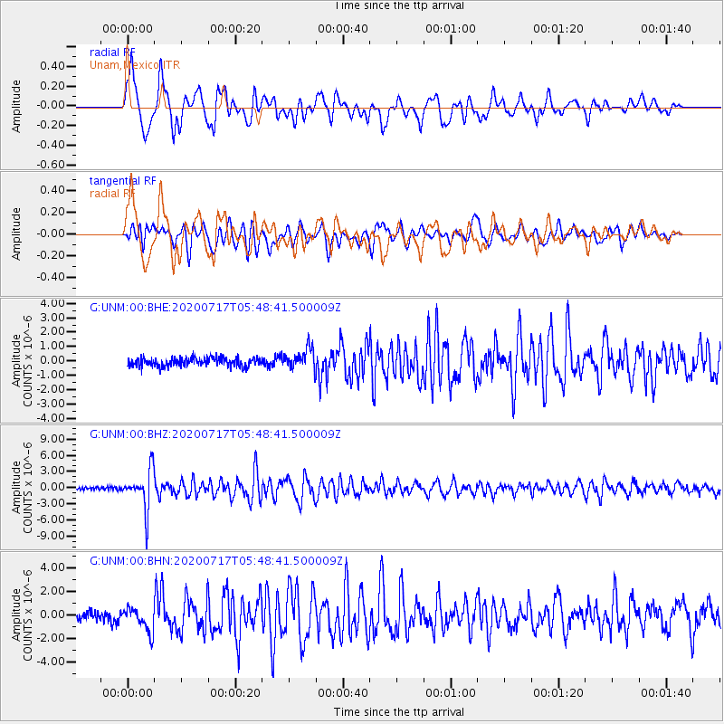
Signal To Noise
| Channel | StoN | STA | LTA |
| G:UNM:00:BHZ:20200717T05:48:41.500009Z | 15.94954 | 3.707019E-6 | 2.3242168E-7 |
| G:UNM:00:BHN:20200717T05:48:41.500009Z | 2.8712022 | 1.0367665E-6 | 3.6109148E-7 |
| G:UNM:00:BHE:20200717T05:48:41.500009Z | 2.4985156 | 7.333327E-7 | 2.9350733E-7 |
| Arrivals |
| Ps | 6.3 SECOND |
| PpPs | 24 SECOND |
| PsPs/PpSs | 30 SECOND |


