You are here: Home > Network List > N4 - Central and EAstern US Network Stations List
> Station 154A Montrose, GA, USA > Earthquake Result Viewer
154A Montrose, GA, USA - Earthquake Result Viewer
| Earthquake location: |
Near Coast Of Northern Chile |
| Earthquake latitude/longitude: |
-20.2/-70.1 |
| Earthquake time(UTC): |
2020/07/17 (199) 05:40:36 GMT |
| Earthquake Depth: |
74 km |
| Earthquake Magnitude: |
5.9 Mww |
| Earthquake Catalog/Contributor: |
NEIC PDE/us |
|
| Network: |
N4 Central and EAstern US Network |
| Station: |
154A Montrose, GA, USA |
| Lat/Lon: |
32.61 N/83.11 W |
| Elevation: |
111 m |
|
| Distance: |
54.0 deg |
| Az: |
346.462 deg |
| Baz: |
164.902 deg |
| Ray Param: |
0.06553657 |
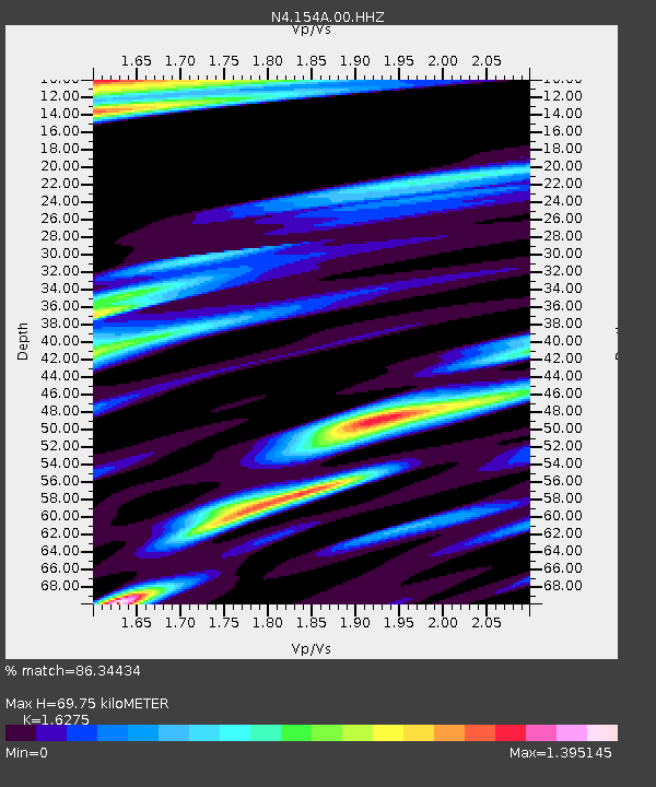
| Estimated Moho Depth: |
69.75 km |
| Estimated Crust Vp/Vs: |
1.63 |
| Assumed Crust Vp: |
6.565 km/s |
| Estimated Crust Vs: |
4.033 km/s |
| Estimated Crust Poisson's Ratio: |
0.20 |
|
| Radial Match: |
86.34434 % |
| Radial Bump: |
327 |
| Transverse Match: |
76.6584 % |
| Transverse Bump: |
373 |
| SOD ConfigId: |
21709731 |
| Insert Time: |
2020-07-31 05:54:57.076 +0000 |
| GWidth: |
2.5 |
| Max Bumps: |
400 |
| Tol: |
0.001 |
|

Signal To Noise
| Channel | StoN | STA | LTA |
| N4:154A:00:HHZ:20200717T05:49:22.199991Z | 24.93784 | 3.5364485E-6 | 1.4181053E-7 |
| N4:154A:00:HH1:20200717T05:49:22.199991Z | 9.857327 | 1.6790132E-6 | 1.7033148E-7 |
| N4:154A:00:HH2:20200717T05:49:22.199991Z | 5.5545955 | 5.822329E-7 | 1.04820025E-7 |
| Arrivals |
| Ps | 7.1 SECOND |
| PpPs | 26 SECOND |
| PsPs/PpSs | 33 SECOND |


