You are here: Home > Network List > N4 - Central and EAstern US Network Stations List
> Station MDND Maddock, ND, USA > Earthquake Result Viewer
MDND Maddock, ND, USA - Earthquake Result Viewer
| Earthquake location: |
Near Coast Of Northern Chile |
| Earthquake latitude/longitude: |
-20.2/-70.1 |
| Earthquake time(UTC): |
2020/07/17 (199) 05:40:36 GMT |
| Earthquake Depth: |
74 km |
| Earthquake Magnitude: |
5.9 Mww |
| Earthquake Catalog/Contributor: |
NEIC PDE/us |
|
| Network: |
N4 Central and EAstern US Network |
| Station: |
MDND Maddock, ND, USA |
| Lat/Lon: |
47.85 N/99.60 W |
| Elevation: |
479 m |
|
| Distance: |
72.7 deg |
| Az: |
339.701 deg |
| Baz: |
151.077 deg |
| Ray Param: |
0.0533028 |
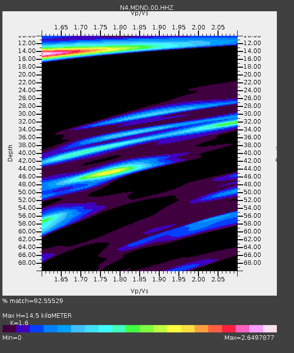
| Estimated Moho Depth: |
14.5 km |
| Estimated Crust Vp/Vs: |
1.60 |
| Assumed Crust Vp: |
6.53 km/s |
| Estimated Crust Vs: |
4.082 km/s |
| Estimated Crust Poisson's Ratio: |
0.18 |
|
| Radial Match: |
92.55529 % |
| Radial Bump: |
400 |
| Transverse Match: |
77.537094 % |
| Transverse Bump: |
400 |
| SOD ConfigId: |
21709731 |
| Insert Time: |
2020-07-31 05:56:24.691 +0000 |
| GWidth: |
2.5 |
| Max Bumps: |
400 |
| Tol: |
0.001 |
|

Signal To Noise
| Channel | StoN | STA | LTA |
| N4:MDND:00:HHZ:20200717T05:51:25.709024Z | 37.57092 | 4.3490027E-6 | 1.1575449E-7 |
| N4:MDND:00:HH1:20200717T05:51:25.709024Z | 9.9022255 | 1.34947E-6 | 1.3627945E-7 |
| N4:MDND:00:HH2:20200717T05:51:25.709024Z | 5.8785205 | 1.2078843E-6 | 2.0547421E-7 |
| Arrivals |
| Ps | 1.4 SECOND |
| PpPs | 5.5 SECOND |
| PsPs/PpSs | 6.9 SECOND |


