You are here: Home > Network List > N4 - Central and EAstern US Network Stations List
> Station Q56A Q56A > Earthquake Result Viewer
Q56A Q56A - Earthquake Result Viewer
| Earthquake location: |
Near Coast Of Northern Chile |
| Earthquake latitude/longitude: |
-20.2/-70.1 |
| Earthquake time(UTC): |
2020/07/17 (199) 05:40:36 GMT |
| Earthquake Depth: |
74 km |
| Earthquake Magnitude: |
5.9 Mww |
| Earthquake Catalog/Contributor: |
NEIC PDE/us |
|
| Network: |
N4 Central and EAstern US Network |
| Station: |
Q56A Q56A |
| Lat/Lon: |
39.04 N/79.19 W |
| Elevation: |
430 m |
|
| Distance: |
59.6 deg |
| Az: |
351.835 deg |
| Baz: |
170.139 deg |
| Ray Param: |
0.061904382 |
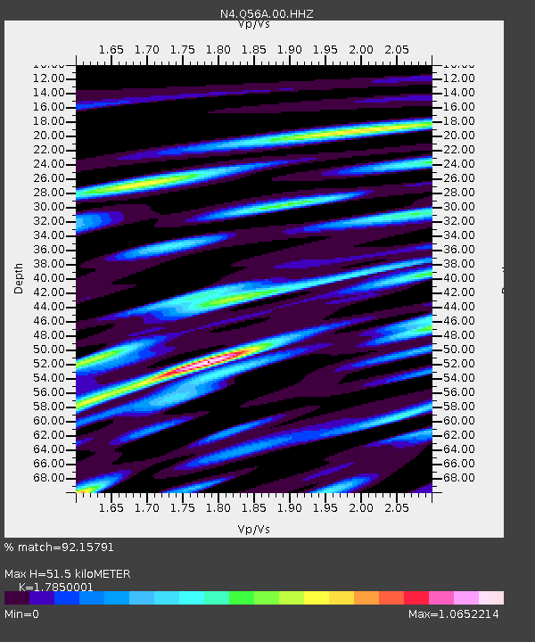
| Estimated Moho Depth: |
51.5 km |
| Estimated Crust Vp/Vs: |
1.79 |
| Assumed Crust Vp: |
6.159 km/s |
| Estimated Crust Vs: |
3.45 km/s |
| Estimated Crust Poisson's Ratio: |
0.27 |
|
| Radial Match: |
92.15791 % |
| Radial Bump: |
400 |
| Transverse Match: |
89.351265 % |
| Transverse Bump: |
400 |
| SOD ConfigId: |
21709731 |
| Insert Time: |
2020-07-31 05:57:04.458 +0000 |
| GWidth: |
2.5 |
| Max Bumps: |
400 |
| Tol: |
0.001 |
|

Signal To Noise
| Channel | StoN | STA | LTA |
| N4:Q56A:00:HHZ:20200717T05:50:01.579019Z | 40.006725 | 3.0723163E-6 | 7.6795E-8 |
| N4:Q56A:00:HH1:20200717T05:50:01.579019Z | 20.575432 | 1.5757984E-6 | 7.65864E-8 |
| N4:Q56A:00:HH2:20200717T05:50:01.579019Z | 8.058111 | 7.8909153E-7 | 9.7925124E-8 |
| Arrivals |
| Ps | 6.9 SECOND |
| PpPs | 22 SECOND |
| PsPs/PpSs | 29 SECOND |


