You are here: Home > Network List > N4 - Central and EAstern US Network Stations List
> Station T45B Paducah, KY, USA > Earthquake Result Viewer
T45B Paducah, KY, USA - Earthquake Result Viewer
| Earthquake location: |
Near Coast Of Northern Chile |
| Earthquake latitude/longitude: |
-20.2/-70.1 |
| Earthquake time(UTC): |
2020/07/17 (199) 05:40:36 GMT |
| Earthquake Depth: |
74 km |
| Earthquake Magnitude: |
5.9 Mww |
| Earthquake Catalog/Contributor: |
NEIC PDE/us |
|
| Network: |
N4 Central and EAstern US Network |
| Station: |
T45B Paducah, KY, USA |
| Lat/Lon: |
37.02 N/88.65 W |
| Elevation: |
136 m |
|
| Distance: |
59.6 deg |
| Az: |
342.862 deg |
| Baz: |
159.775 deg |
| Ray Param: |
0.061910078 |
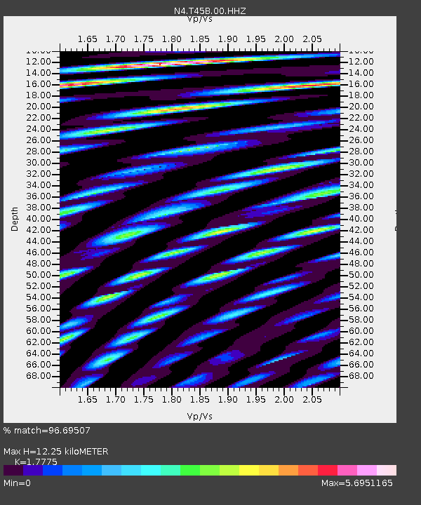
| Estimated Moho Depth: |
12.25 km |
| Estimated Crust Vp/Vs: |
1.78 |
| Assumed Crust Vp: |
6.444 km/s |
| Estimated Crust Vs: |
3.625 km/s |
| Estimated Crust Poisson's Ratio: |
0.27 |
|
| Radial Match: |
96.69507 % |
| Radial Bump: |
400 |
| Transverse Match: |
93.498795 % |
| Transverse Bump: |
400 |
| SOD ConfigId: |
21709731 |
| Insert Time: |
2020-07-31 05:57:32.261 +0000 |
| GWidth: |
2.5 |
| Max Bumps: |
400 |
| Tol: |
0.001 |
|

Signal To Noise
| Channel | StoN | STA | LTA |
| N4:T45B:00:HHZ:20200717T05:50:01.519998Z | 40.657646 | 5.6104554E-6 | 1.3799263E-7 |
| N4:T45B:00:HH1:20200717T05:50:01.519998Z | 99.48097 | 1.1338522E-5 | 1.13976796E-7 |
| N4:T45B:00:HH2:20200717T05:50:01.519998Z | 24.078753 | 2.5558172E-6 | 1.0614408E-7 |
| Arrivals |
| Ps | 1.5 SECOND |
| PpPs | 5.0 SECOND |
| PsPs/PpSs | 6.6 SECOND |


