You are here: Home > Network List > N4 - Central and EAstern US Network Stations List
> Station Y60A Bolivia, NC, USA > Earthquake Result Viewer
Y60A Bolivia, NC, USA - Earthquake Result Viewer
| Earthquake location: |
Near Coast Of Northern Chile |
| Earthquake latitude/longitude: |
-20.2/-70.1 |
| Earthquake time(UTC): |
2020/07/17 (199) 05:40:36 GMT |
| Earthquake Depth: |
74 km |
| Earthquake Magnitude: |
5.9 Mww |
| Earthquake Catalog/Contributor: |
NEIC PDE/us |
|
| Network: |
N4 Central and EAstern US Network |
| Station: |
Y60A Bolivia, NC, USA |
| Lat/Lon: |
34.00 N/78.22 W |
| Elevation: |
7.0 m |
|
| Distance: |
54.5 deg |
| Az: |
351.756 deg |
| Baz: |
170.672 deg |
| Ray Param: |
0.06521929 |
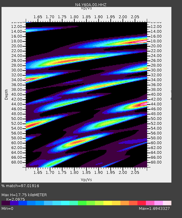
| Estimated Moho Depth: |
17.75 km |
| Estimated Crust Vp/Vs: |
2.10 |
| Assumed Crust Vp: |
6.565 km/s |
| Estimated Crust Vs: |
3.13 km/s |
| Estimated Crust Poisson's Ratio: |
0.35 |
|
| Radial Match: |
97.01916 % |
| Radial Bump: |
400 |
| Transverse Match: |
83.73098 % |
| Transverse Bump: |
400 |
| SOD ConfigId: |
21709731 |
| Insert Time: |
2020-07-31 05:58:10.373 +0000 |
| GWidth: |
2.5 |
| Max Bumps: |
400 |
| Tol: |
0.001 |
|

Signal To Noise
| Channel | StoN | STA | LTA |
| N4:Y60A:00:HHZ:20200717T05:49:25.749979Z | 37.90262 | 5.9666227E-6 | 1.574198E-7 |
| N4:Y60A:00:HH1:20200717T05:49:25.749979Z | 18.982996 | 4.0943764E-6 | 2.1568651E-7 |
| N4:Y60A:00:HH2:20200717T05:49:25.749979Z | 5.6486197 | 1.061339E-6 | 1.8789352E-7 |
| Arrivals |
| Ps | 3.1 SECOND |
| PpPs | 8.0 SECOND |
| PsPs/PpSs | 11 SECOND |


