You are here: Home > Network List > O2 - Oklahoma Consolidated Temporary Seismic Networks Stations List
> Station FW02 Waynoka, Oklahoma, USA > Earthquake Result Viewer
FW02 Waynoka, Oklahoma, USA - Earthquake Result Viewer
| Earthquake location: |
Near Coast Of Northern Chile |
| Earthquake latitude/longitude: |
-20.2/-70.1 |
| Earthquake time(UTC): |
2020/07/17 (199) 05:40:36 GMT |
| Earthquake Depth: |
74 km |
| Earthquake Magnitude: |
5.9 Mww |
| Earthquake Catalog/Contributor: |
NEIC PDE/us |
|
| Network: |
O2 Oklahoma Consolidated Temporary Seismic Networks |
| Station: |
FW02 Waynoka, Oklahoma, USA |
| Lat/Lon: |
36.38 N/98.73 W |
| Elevation: |
434 m |
|
| Distance: |
62.5 deg |
| Az: |
334.181 deg |
| Baz: |
149.551 deg |
| Ray Param: |
0.060022414 |
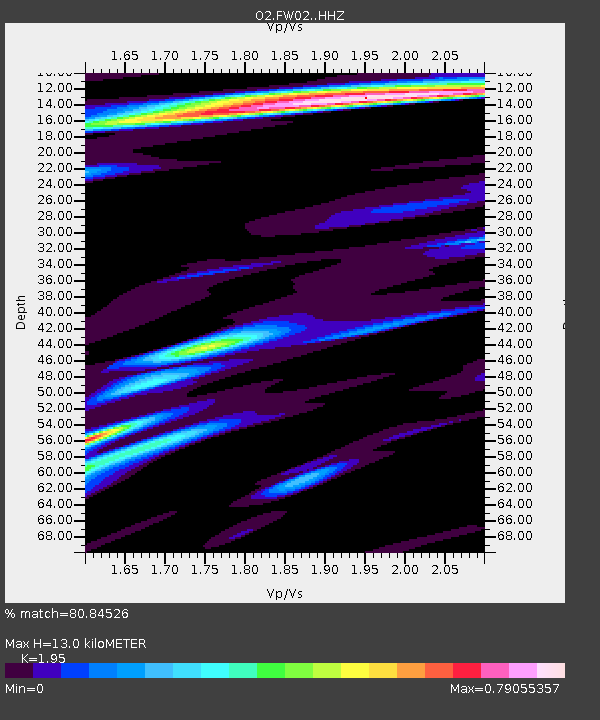
| Estimated Moho Depth: |
13.0 km |
| Estimated Crust Vp/Vs: |
1.95 |
| Assumed Crust Vp: |
6.426 km/s |
| Estimated Crust Vs: |
3.295 km/s |
| Estimated Crust Poisson's Ratio: |
0.32 |
|
| Radial Match: |
80.84526 % |
| Radial Bump: |
400 |
| Transverse Match: |
67.32942 % |
| Transverse Bump: |
400 |
| SOD ConfigId: |
21709731 |
| Insert Time: |
2020-07-31 06:00:47.353 +0000 |
| GWidth: |
2.5 |
| Max Bumps: |
400 |
| Tol: |
0.001 |
|

Signal To Noise
| Channel | StoN | STA | LTA |
| O2:FW02: :HHZ:20200717T05:50:21.110025Z | 19.370766 | 1.8298451E-6 | 9.446426E-8 |
| O2:FW02: :HHN:20200717T05:50:21.110025Z | 5.684019 | 7.5131135E-7 | 1.321796E-7 |
| O2:FW02: :HHE:20200717T05:50:21.110025Z | 7.4821796 | 5.8295996E-7 | 7.791312E-8 |
| Arrivals |
| Ps | 2.0 SECOND |
| PpPs | 5.7 SECOND |
| PsPs/PpSs | 7.7 SECOND |


