You are here: Home > Network List > PE - Penn State Network Stations List
> Station PACH Chapman State Park, Clarendon, PA > Earthquake Result Viewer
PACH Chapman State Park, Clarendon, PA - Earthquake Result Viewer
| Earthquake location: |
Near Coast Of Northern Chile |
| Earthquake latitude/longitude: |
-20.2/-70.1 |
| Earthquake time(UTC): |
2020/07/17 (199) 05:40:36 GMT |
| Earthquake Depth: |
74 km |
| Earthquake Magnitude: |
5.9 Mww |
| Earthquake Catalog/Contributor: |
NEIC PDE/us |
|
| Network: |
PE Penn State Network |
| Station: |
PACH Chapman State Park, Clarendon, PA |
| Lat/Lon: |
41.76 N/79.17 W |
| Elevation: |
431 m |
|
| Distance: |
62.2 deg |
| Az: |
352.373 deg |
| Baz: |
170.411 deg |
| Ray Param: |
0.060165573 |
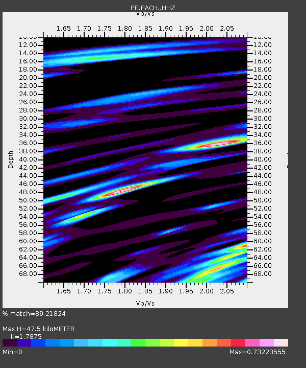
| Estimated Moho Depth: |
47.5 km |
| Estimated Crust Vp/Vs: |
1.79 |
| Assumed Crust Vp: |
6.121 km/s |
| Estimated Crust Vs: |
3.424 km/s |
| Estimated Crust Poisson's Ratio: |
0.27 |
|
| Radial Match: |
89.21824 % |
| Radial Bump: |
400 |
| Transverse Match: |
84.96868 % |
| Transverse Bump: |
400 |
| SOD ConfigId: |
21709731 |
| Insert Time: |
2020-07-31 06:03:26.541 +0000 |
| GWidth: |
2.5 |
| Max Bumps: |
400 |
| Tol: |
0.001 |
|

Signal To Noise
| Channel | StoN | STA | LTA |
| PE:PACH: :HHZ:20200717T05:50:19.660013Z | 21.054665 | 2.3785383E-6 | 1.12969666E-7 |
| PE:PACH: :HHN:20200717T05:50:19.660013Z | 7.1748796 | 7.4985365E-7 | 1.04510974E-7 |
| PE:PACH: :HHE:20200717T05:50:19.660013Z | 1.3932636 | 1.6052371E-7 | 1.1521417E-7 |
| Arrivals |
| Ps | 6.4 SECOND |
| PpPs | 21 SECOND |
| PsPs/PpSs | 27 SECOND |


