You are here: Home > Network List > PR - Puerto Rico Seismic Network (PRSN) & Puerto Rico Strong Motion Program (PRSMP) Stations List
> Station MLPR PRSN > Earthquake Result Viewer
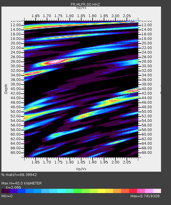
MLPR PRSN - Earthquake Result Viewer
| Earthquake location: |
Near Coast Of Northern Chile |
| Earthquake latitude/longitude: |
-20.2/-70.1 |
| Earthquake time(UTC): |
2020/07/17 (199) 05:40:36 GMT |
| Earthquake Depth: |
74 km |
| Earthquake Magnitude: |
5.9 Mww |
| Earthquake Catalog/Contributor: |
NEIC PDE/us |
|
| Network: |
PR Puerto Rico Seismic Network (PRSN) & Puerto Rico Strong Motion Program (PRSMP) |
| Station: |
MLPR PRSN |
| Lat/Lon: |
17.97 N/67.04 W |
| Elevation: |
31 m |
|
| Distance: |
38.1 deg |
| Az: |
4.78 deg |
| Baz: |
184.715 deg |
| Ray Param: |
0.075563625 |
| Estimated Moho Depth: |
40.0 km |
| Estimated Crust Vp/Vs: |
2.10 |
| Assumed Crust Vp: |
4.082 km/s |
| Estimated Crust Vs: |
1.949 km/s |
| Estimated Crust Poisson's Ratio: |
0.35 |
|
| Radial Match: |
86.39942 % |
| Radial Bump: |
400 |
| Transverse Match: |
79.151855 % |
| Transverse Bump: |
400 |
| SOD ConfigId: |
21709731 |
| Insert Time: |
2020-07-31 06:04:28.132 +0000 |
| GWidth: |
2.5 |
| Max Bumps: |
400 |
| Tol: |
0.001 |
|

Signal To Noise
| Channel | StoN | STA | LTA |
| PR:MLPR:00:HHZ:20200717T05:47:17.549997Z | 7.721799 | 1.290979E-6 | 1.671863E-7 |
| PR:MLPR:00:HH1:20200717T05:47:17.549997Z | 4.0828476 | 5.1630263E-7 | 1.264565E-7 |
| PR:MLPR:00:HH2:20200717T05:47:17.549997Z | 2.8477256 | 3.9915798E-7 | 1.4016729E-7 |
| Arrivals |
| Ps | 11 SECOND |
| PpPs | 30 SECOND |
| PsPs/PpSs | 41 SECOND |


