You are here: Home > Network List > TX - Texas Seismological Network Stations List
> Station FW07 Weatherford > Earthquake Result Viewer
FW07 Weatherford - Earthquake Result Viewer
| Earthquake location: |
Near Coast Of Northern Chile |
| Earthquake latitude/longitude: |
-20.2/-70.1 |
| Earthquake time(UTC): |
2020/07/17 (199) 05:40:36 GMT |
| Earthquake Depth: |
74 km |
| Earthquake Magnitude: |
5.9 Mww |
| Earthquake Catalog/Contributor: |
NEIC PDE/us |
|
| Network: |
TX Texas Seismological Network |
| Station: |
FW07 Weatherford |
| Lat/Lon: |
32.70 N/97.79 W |
| Elevation: |
311 m |
|
| Distance: |
58.9 deg |
| Az: |
332.815 deg |
| Baz: |
149.414 deg |
| Ray Param: |
0.062345464 |
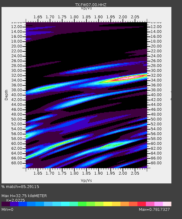
| Estimated Moho Depth: |
32.75 km |
| Estimated Crust Vp/Vs: |
2.02 |
| Assumed Crust Vp: |
6.38 km/s |
| Estimated Crust Vs: |
3.155 km/s |
| Estimated Crust Poisson's Ratio: |
0.34 |
|
| Radial Match: |
85.29115 % |
| Radial Bump: |
332 |
| Transverse Match: |
67.60638 % |
| Transverse Bump: |
400 |
| SOD ConfigId: |
21709731 |
| Insert Time: |
2020-07-31 06:07:19.242 +0000 |
| GWidth: |
2.5 |
| Max Bumps: |
400 |
| Tol: |
0.001 |
|

Signal To Noise
| Channel | StoN | STA | LTA |
| TX:FW07:00:HHZ:20200717T05:49:57.009988Z | 21.390495 | 2.2503668E-6 | 1.05204045E-7 |
| TX:FW07:00:HH1:20200717T05:49:57.009988Z | 13.780903 | 9.21565E-7 | 6.6872616E-8 |
| TX:FW07:00:HH2:20200717T05:49:57.009988Z | 3.8200216 | 4.4243703E-7 | 1.15820555E-7 |
| Arrivals |
| Ps | 5.5 SECOND |
| PpPs | 15 SECOND |
| PsPs/PpSs | 20 SECOND |


