You are here: Home > Network List > TX - Texas Seismological Network Stations List
> Station FW09 Farmers Branch > Earthquake Result Viewer
FW09 Farmers Branch - Earthquake Result Viewer
| Earthquake location: |
Near Coast Of Northern Chile |
| Earthquake latitude/longitude: |
-20.2/-70.1 |
| Earthquake time(UTC): |
2020/07/17 (199) 05:40:36 GMT |
| Earthquake Depth: |
74 km |
| Earthquake Magnitude: |
5.9 Mww |
| Earthquake Catalog/Contributor: |
NEIC PDE/us |
|
| Network: |
TX Texas Seismological Network |
| Station: |
FW09 Farmers Branch |
| Lat/Lon: |
32.92 N/96.91 W |
| Elevation: |
311 m |
|
| Distance: |
58.7 deg |
| Az: |
333.686 deg |
| Baz: |
150.336 deg |
| Ray Param: |
0.062459763 |
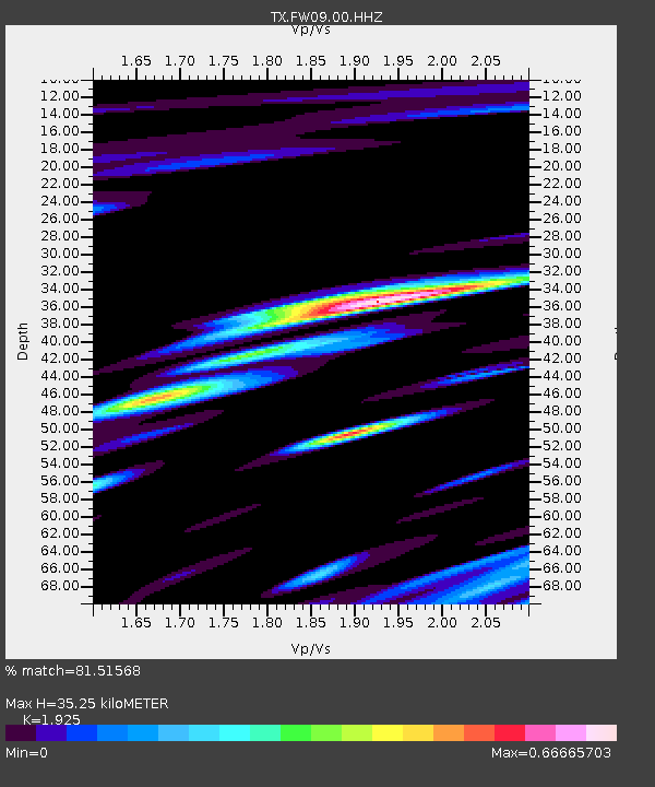
| Estimated Moho Depth: |
35.25 km |
| Estimated Crust Vp/Vs: |
1.92 |
| Assumed Crust Vp: |
6.38 km/s |
| Estimated Crust Vs: |
3.315 km/s |
| Estimated Crust Poisson's Ratio: |
0.32 |
|
| Radial Match: |
81.51568 % |
| Radial Bump: |
400 |
| Transverse Match: |
52.875282 % |
| Transverse Bump: |
400 |
| SOD ConfigId: |
21709731 |
| Insert Time: |
2020-07-31 06:07:22.115 +0000 |
| GWidth: |
2.5 |
| Max Bumps: |
400 |
| Tol: |
0.001 |
|

Signal To Noise
| Channel | StoN | STA | LTA |
| TX:FW09:00:HHZ:20200717T05:49:55.780008Z | 5.9328957 | 3.7000082E-6 | 6.236429E-7 |
| TX:FW09:00:HH1:20200717T05:49:55.780008Z | 3.0803647 | 1.9653871E-6 | 6.3803714E-7 |
| TX:FW09:00:HH2:20200717T05:49:55.780008Z | 1.1533647 | 1.1597897E-6 | 1.0055707E-6 |
| Arrivals |
| Ps | 5.3 SECOND |
| PpPs | 15 SECOND |
| PsPs/PpSs | 21 SECOND |


