You are here: Home > Network List > TX - Texas Seismological Network Stations List
> Station MB02 Rankin > Earthquake Result Viewer
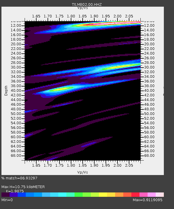
MB02 Rankin - Earthquake Result Viewer
| Earthquake location: |
Near Coast Of Northern Chile |
| Earthquake latitude/longitude: |
-20.2/-70.1 |
| Earthquake time(UTC): |
2020/07/17 (199) 05:40:36 GMT |
| Earthquake Depth: |
74 km |
| Earthquake Magnitude: |
5.9 Mww |
| Earthquake Catalog/Contributor: |
NEIC PDE/us |
|
| Network: |
TX Texas Seismological Network |
| Station: |
MB02 Rankin |
| Lat/Lon: |
31.20 N/102.04 W |
| Elevation: |
768 m |
|
| Distance: |
59.6 deg |
| Az: |
328.336 deg |
| Baz: |
144.883 deg |
| Ray Param: |
0.061878707 |
| Estimated Moho Depth: |
10.75 km |
| Estimated Crust Vp/Vs: |
1.99 |
| Assumed Crust Vp: |
6.121 km/s |
| Estimated Crust Vs: |
3.08 km/s |
| Estimated Crust Poisson's Ratio: |
0.33 |
|
| Radial Match: |
86.93297 % |
| Radial Bump: |
398 |
| Transverse Match: |
72.52019 % |
| Transverse Bump: |
400 |
| SOD ConfigId: |
21709731 |
| Insert Time: |
2020-07-31 06:07:36.377 +0000 |
| GWidth: |
2.5 |
| Max Bumps: |
400 |
| Tol: |
0.001 |
|

Signal To Noise
| Channel | StoN | STA | LTA |
| TX:MB02:00:HHZ:20200717T05:50:01.840005Z | 35.93358 | 1.3123438E-6 | 3.6521378E-8 |
| TX:MB02:00:HH1:20200717T05:50:01.840005Z | 11.550829 | 4.5509555E-7 | 3.9399385E-8 |
| TX:MB02:00:HH2:20200717T05:50:01.840005Z | 16.62466 | 6.818073E-7 | 4.1011802E-8 |
| Arrivals |
| Ps | 1.8 SECOND |
| PpPs | 5.1 SECOND |
| PsPs/PpSs | 6.9 SECOND |


