You are here: Home > Network List > TX - Texas Seismological Network Stations List
> Station PB06 Permian Basin 6 > Earthquake Result Viewer
PB06 Permian Basin 6 - Earthquake Result Viewer

| Earthquake location: |
Near Coast Of Northern Chile |
| Earthquake latitude/longitude: |
-20.2/-70.1 |
| Earthquake time(UTC): |
2020/07/17 (199) 05:40:36 GMT |
| Earthquake Depth: |
74 km |
| Earthquake Magnitude: |
5.9 Mww |
| Earthquake Catalog/Contributor: |
NEIC PDE/us |
|
| Network: |
TX Texas Seismological Network |
| Station: |
PB06 Permian Basin 6 |
| Lat/Lon: |
31.65 N/103.22 W |
| Elevation: |
831 m |
|
| Distance: |
60.6 deg |
| Az: |
327.689 deg |
| Baz: |
143.949 deg |
| Ray Param: |
0.06127017 |
| Estimated Moho Depth: |
20.5 km |
| Estimated Crust Vp/Vs: |
1.93 |
| Assumed Crust Vp: |
6.121 km/s |
| Estimated Crust Vs: |
3.171 km/s |
| Estimated Crust Poisson's Ratio: |
0.32 |
|
| Radial Match: |
80.741714 % |
| Radial Bump: |
400 |
| Transverse Match: |
73.82604 % |
| Transverse Bump: |
400 |
| SOD ConfigId: |
21709731 |
| Insert Time: |
2020-07-31 06:07:55.731 +0000 |
| GWidth: |
2.5 |
| Max Bumps: |
400 |
| Tol: |
0.001 |
|
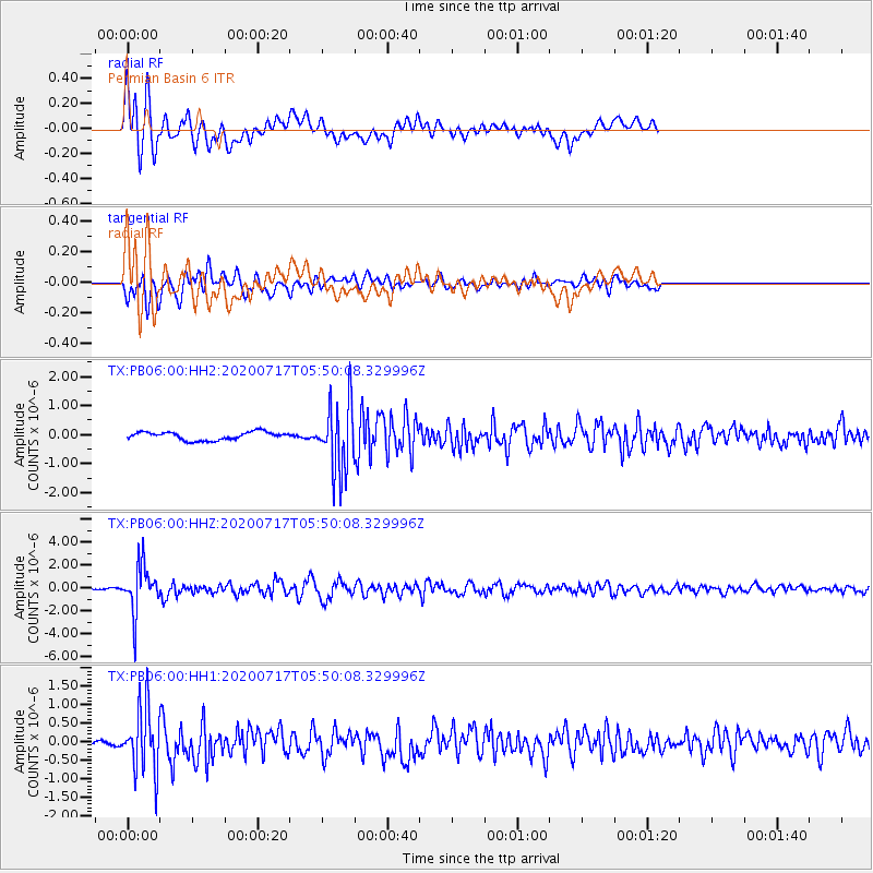
Signal To Noise
| Channel | StoN | STA | LTA |
| TX:PB06:00:HHZ:20200717T05:50:08.329996Z | 18.928972 | 2.0639181E-6 | 1.0903487E-7 |
| TX:PB06:00:HH1:20200717T05:50:08.329996Z | 7.605463 | 8.7175766E-7 | 1.14622566E-7 |
| TX:PB06:00:HH2:20200717T05:50:08.329996Z | 8.414669 | 1.1905281E-6 | 1.4148246E-7 |
| Arrivals |
| Ps | 3.2 SECOND |
| PpPs | 9.4 SECOND |
| PsPs/PpSs | 13 SECOND |


