You are here: Home > Network List > TX - Texas Seismological Network Stations List
> Station PB11 China Draw > Earthquake Result Viewer
PB11 China Draw - Earthquake Result Viewer
| Earthquake location: |
Near Coast Of Northern Chile |
| Earthquake latitude/longitude: |
-20.2/-70.1 |
| Earthquake time(UTC): |
2020/07/17 (199) 05:40:36 GMT |
| Earthquake Depth: |
74 km |
| Earthquake Magnitude: |
5.9 Mww |
| Earthquake Catalog/Contributor: |
NEIC PDE/us |
|
| Network: |
TX Texas Seismological Network |
| Station: |
PB11 China Draw |
| Lat/Lon: |
31.94 N/104.03 W |
| Elevation: |
915 m |
|
| Distance: |
61.2 deg |
| Az: |
327.244 deg |
| Baz: |
143.304 deg |
| Ray Param: |
0.06083602 |
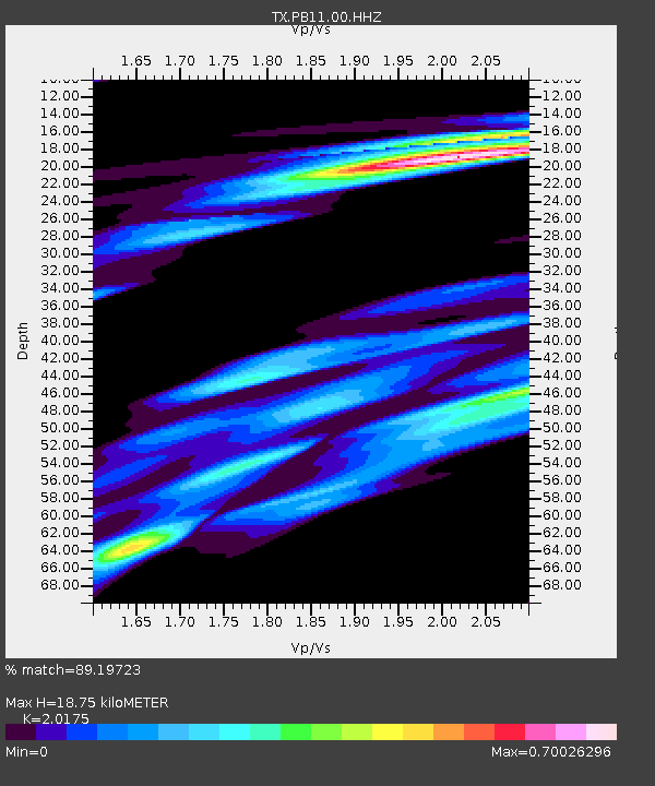
| Estimated Moho Depth: |
18.75 km |
| Estimated Crust Vp/Vs: |
2.02 |
| Assumed Crust Vp: |
6.361 km/s |
| Estimated Crust Vs: |
3.153 km/s |
| Estimated Crust Poisson's Ratio: |
0.34 |
|
| Radial Match: |
89.19723 % |
| Radial Bump: |
400 |
| Transverse Match: |
77.321014 % |
| Transverse Bump: |
400 |
| SOD ConfigId: |
21709731 |
| Insert Time: |
2020-07-31 06:07:59.434 +0000 |
| GWidth: |
2.5 |
| Max Bumps: |
400 |
| Tol: |
0.001 |
|

Signal To Noise
| Channel | StoN | STA | LTA |
| TX:PB11:00:HHZ:20200717T05:50:12.679971Z | 32.677788 | 3.6649094E-6 | 1.1215292E-7 |
| TX:PB11:00:HH1:20200717T05:50:12.679971Z | 10.00466 | 6.675044E-7 | 6.671935E-8 |
| TX:PB11:00:HH2:20200717T05:50:12.679971Z | 5.823991 | 8.086588E-7 | 1.388496E-7 |
| Arrivals |
| Ps | 3.1 SECOND |
| PpPs | 8.6 SECOND |
| PsPs/PpSs | 12 SECOND |


