You are here: Home > Network List > TX - Texas Seismological Network Stations List
> Station SN07 Snyder 07 > Earthquake Result Viewer
SN07 Snyder 07 - Earthquake Result Viewer
| Earthquake location: |
Near Coast Of Northern Chile |
| Earthquake latitude/longitude: |
-20.2/-70.1 |
| Earthquake time(UTC): |
2020/07/17 (199) 05:40:36 GMT |
| Earthquake Depth: |
74 km |
| Earthquake Magnitude: |
5.9 Mww |
| Earthquake Catalog/Contributor: |
NEIC PDE/us |
|
| Network: |
TX Texas Seismological Network |
| Station: |
SN07 Snyder 07 |
| Lat/Lon: |
33.09 N/100.89 W |
| Elevation: |
620 m |
|
| Distance: |
60.6 deg |
| Az: |
330.488 deg |
| Baz: |
146.563 deg |
| Ray Param: |
0.06122938 |
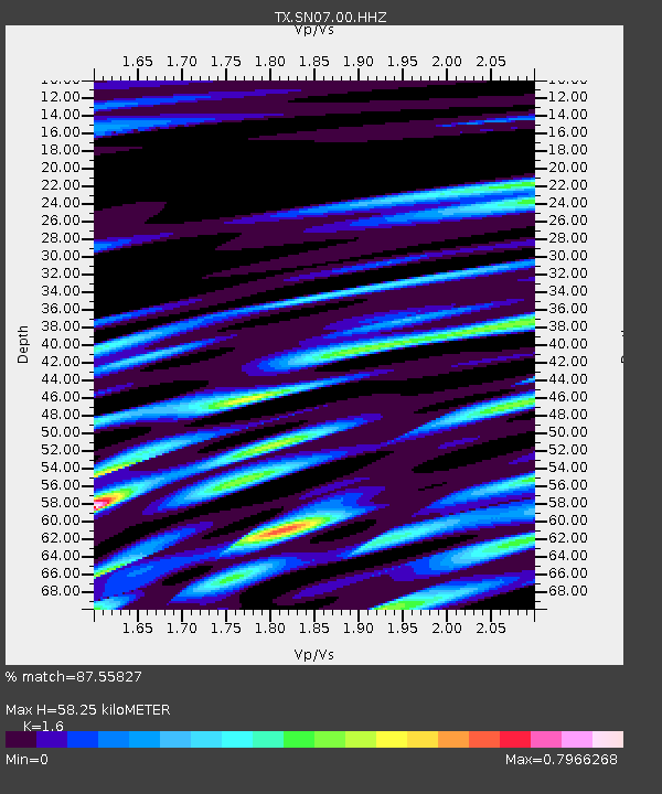
| Estimated Moho Depth: |
58.25 km |
| Estimated Crust Vp/Vs: |
1.60 |
| Assumed Crust Vp: |
6.426 km/s |
| Estimated Crust Vs: |
4.016 km/s |
| Estimated Crust Poisson's Ratio: |
0.18 |
|
| Radial Match: |
87.55827 % |
| Radial Bump: |
400 |
| Transverse Match: |
63.365116 % |
| Transverse Bump: |
400 |
| SOD ConfigId: |
21709731 |
| Insert Time: |
2020-07-31 06:08:28.136 +0000 |
| GWidth: |
2.5 |
| Max Bumps: |
400 |
| Tol: |
0.001 |
|

Signal To Noise
| Channel | StoN | STA | LTA |
| TX:SN07:00:HHZ:20200717T05:50:08.74003Z | 26.284271 | 2.3636057E-6 | 8.992472E-8 |
| TX:SN07:00:HH1:20200717T05:50:08.74003Z | 12.830981 | 8.436488E-7 | 6.575092E-8 |
| TX:SN07:00:HH2:20200717T05:50:08.74003Z | 7.3608727 | 5.418688E-7 | 7.361476E-8 |
| Arrivals |
| Ps | 5.7 SECOND |
| PpPs | 22 SECOND |
| PsPs/PpSs | 28 SECOND |


