You are here: Home > Network List > US - United States National Seismic Network Stations List
> Station NEW Newport, Washington, USA > Earthquake Result Viewer
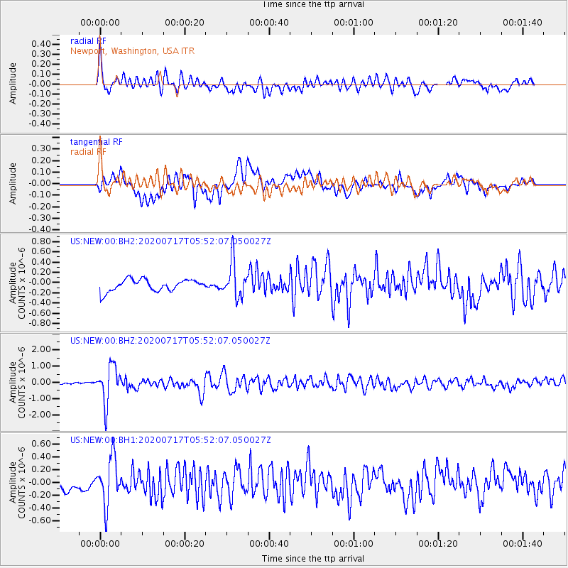
NEW Newport, Washington, USA - Earthquake Result Viewer
*The percent match for this event was below the threshold and hence no stack was calculated.
| Earthquake location: |
Near Coast Of Northern Chile |
| Earthquake latitude/longitude: |
-20.2/-70.1 |
| Earthquake time(UTC): |
2020/07/17 (199) 05:40:36 GMT |
| Earthquake Depth: |
74 km |
| Earthquake Magnitude: |
5.9 Mww |
| Earthquake Catalog/Contributor: |
NEIC PDE/us |
|
| Network: |
US United States National Seismic Network |
| Station: |
NEW Newport, Washington, USA |
| Lat/Lon: |
48.26 N/117.12 W |
| Elevation: |
760 m |
|
| Distance: |
80.1 deg |
| Az: |
330.268 deg |
| Baz: |
135.816 deg |
| Ray Param: |
$rayparam |
*The percent match for this event was below the threshold and hence was not used in the summary stack. |
|
| Radial Match: |
72.21947 % |
| Radial Bump: |
400 |
| Transverse Match: |
59.48224 % |
| Transverse Bump: |
400 |
| SOD ConfigId: |
21709731 |
| Insert Time: |
2020-07-31 06:10:35.181 +0000 |
| GWidth: |
2.5 |
| Max Bumps: |
400 |
| Tol: |
0.001 |
|
Signal To Noise
| Channel | StoN | STA | LTA |
| US:NEW:00:BHZ:20200717T05:52:07.050027Z | 11.842983 | 1.177187E-6 | 9.9399536E-8 |
| US:NEW:00:BH1:20200717T05:52:07.050027Z | 4.021436 | 3.737964E-7 | 9.295097E-8 |
| US:NEW:00:BH2:20200717T05:52:07.050027Z | 3.121353 | 3.562867E-7 | 1.1414497E-7 |
| Arrivals |
| Ps | |
| PpPs | |
| PsPs/PpSs | |


