You are here: Home > Network List > UU - University of Utah Regional Network Stations List
> Station SZCU Shurtz Canyon, UT, USA > Earthquake Result Viewer
SZCU Shurtz Canyon, UT, USA - Earthquake Result Viewer
| Earthquake location: |
Near Coast Of Northern Chile |
| Earthquake latitude/longitude: |
-20.2/-70.1 |
| Earthquake time(UTC): |
2020/07/17 (199) 05:40:36 GMT |
| Earthquake Depth: |
74 km |
| Earthquake Magnitude: |
5.9 Mww |
| Earthquake Catalog/Contributor: |
NEIC PDE/us |
|
| Network: |
UU University of Utah Regional Network |
| Station: |
SZCU Shurtz Canyon, UT, USA |
| Lat/Lon: |
37.60 N/113.09 W |
| Elevation: |
2026 m |
|
| Distance: |
70.3 deg |
| Az: |
324.912 deg |
| Baz: |
137.191 deg |
| Ray Param: |
0.05491826 |
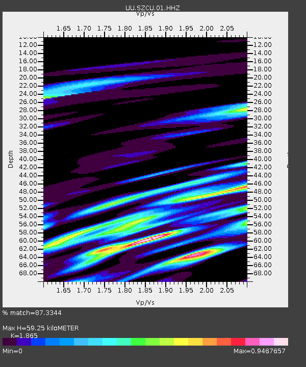
| Estimated Moho Depth: |
59.25 km |
| Estimated Crust Vp/Vs: |
1.87 |
| Assumed Crust Vp: |
6.194 km/s |
| Estimated Crust Vs: |
3.321 km/s |
| Estimated Crust Poisson's Ratio: |
0.30 |
|
| Radial Match: |
87.3344 % |
| Radial Bump: |
364 |
| Transverse Match: |
74.38988 % |
| Transverse Bump: |
400 |
| SOD ConfigId: |
21709731 |
| Insert Time: |
2020-07-31 06:11:45.066 +0000 |
| GWidth: |
2.5 |
| Max Bumps: |
400 |
| Tol: |
0.001 |
|

Signal To Noise
| Channel | StoN | STA | LTA |
| UU:SZCU:01:HHZ:20200717T05:51:11.030008Z | 21.990005 | 6.472894E-8 | 2.9435616E-9 |
| UU:SZCU:01:HHN:20200717T05:51:11.030008Z | 4.075399 | 1.8806793E-8 | 4.614712E-9 |
| UU:SZCU:01:HHE:20200717T05:51:11.030008Z | 7.6166573 | 2.3293513E-8 | 3.0582332E-9 |
| Arrivals |
| Ps | 8.5 SECOND |
| PpPs | 27 SECOND |
| PsPs/PpSs | 35 SECOND |


