You are here: Home > Network List > NO - Norwegian Seismic Array Network Stations List
> Station SPB3 > Earthquake Result Viewer
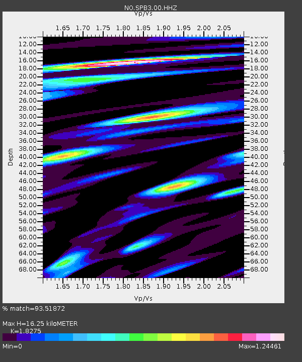
SPB3 - Earthquake Result Viewer
| Earthquake location: |
Leyte, Philippines |
| Earthquake latitude/longitude: |
11.1/124.6 |
| Earthquake time(UTC): |
2017/07/06 (187) 08:03:57 GMT |
| Earthquake Depth: |
6.5 km |
| Earthquake Magnitude: |
6.5 mww |
| Earthquake Catalog/Contributor: |
NEIC PDE/us |
|
| Network: |
NO Norwegian Seismic Array Network |
| Station: |
SPB3 |
| Lat/Lon: |
78.17 N/16.36 E |
| Elevation: |
234 m |
|
| Distance: |
82.9 deg |
| Az: |
348.616 deg |
| Baz: |
69.922 deg |
| Ray Param: |
0.04658525 |
| Estimated Moho Depth: |
16.25 km |
| Estimated Crust Vp/Vs: |
1.83 |
| Assumed Crust Vp: |
6.545 km/s |
| Estimated Crust Vs: |
3.582 km/s |
| Estimated Crust Poisson's Ratio: |
0.29 |
|
| Radial Match: |
93.51872 % |
| Radial Bump: |
400 |
| Transverse Match: |
89.726456 % |
| Transverse Bump: |
400 |
| SOD ConfigId: |
2140511 |
| Insert Time: |
2017-07-19 23:59:26.655 +0000 |
| GWidth: |
2.5 |
| Max Bumps: |
400 |
| Tol: |
0.001 |
|

Signal To Noise
| Channel | StoN | STA | LTA |
| NO:SPB3:00:HHZ:20170706T08:15:51.336997Z | 19.734509 | 1.215369E-6 | 6.158598E-8 |
| NO:SPB3:00:HHN:20170706T08:15:51.336997Z | 3.899491 | 2.4817697E-7 | 6.3643434E-8 |
| NO:SPB3:00:HHE:20170706T08:15:51.336997Z | 6.8098993 | 4.1363162E-7 | 6.073976E-8 |
| Arrivals |
| Ps | 2.1 SECOND |
| PpPs | 6.8 SECOND |
| PsPs/PpSs | 8.9 SECOND |


