You are here: Home > Network List > AK - Alaska Regional Network Stations List
> Station PS12 TAPS Pump Station 12, AK, USA > Earthquake Result Viewer
PS12 TAPS Pump Station 12, AK, USA - Earthquake Result Viewer
| Earthquake location: |
Andaman Islands, India Region |
| Earthquake latitude/longitude: |
12.0/94.9 |
| Earthquake time(UTC): |
2020/07/17 (199) 14:03:42 GMT |
| Earthquake Depth: |
10 km |
| Earthquake Magnitude: |
6.1 mww |
| Earthquake Catalog/Contributor: |
NEIC PDE/us |
|
| Network: |
AK Alaska Regional Network |
| Station: |
PS12 TAPS Pump Station 12, AK, USA |
| Lat/Lon: |
61.47 N/145.15 W |
| Elevation: |
563 m |
|
| Distance: |
93.1 deg |
| Az: |
24.611 deg |
| Baz: |
301.907 deg |
| Ray Param: |
0.04134162 |
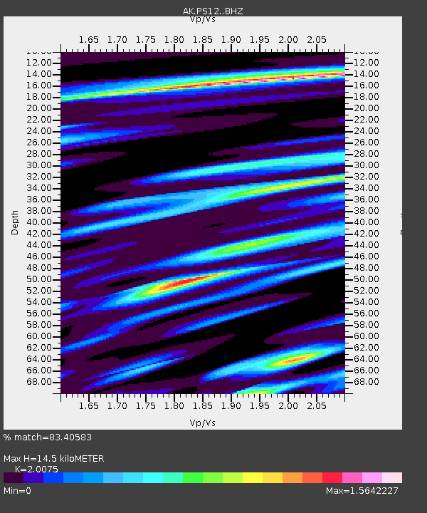
| Estimated Moho Depth: |
14.5 km |
| Estimated Crust Vp/Vs: |
2.01 |
| Assumed Crust Vp: |
6.566 km/s |
| Estimated Crust Vs: |
3.271 km/s |
| Estimated Crust Poisson's Ratio: |
0.33 |
|
| Radial Match: |
83.40583 % |
| Radial Bump: |
400 |
| Transverse Match: |
73.7173 % |
| Transverse Bump: |
400 |
| SOD ConfigId: |
21709731 |
| Insert Time: |
2020-07-31 14:05:24.925 +0000 |
| GWidth: |
2.5 |
| Max Bumps: |
400 |
| Tol: |
0.001 |
|

Signal To Noise
| Channel | StoN | STA | LTA |
| AK:PS12: :BHZ:20200717T14:16:24.288017Z | 0.9794082 | 8.075215E-8 | 8.2449944E-8 |
| AK:PS12: :BHN:20200717T14:16:24.288017Z | 0.82498 | 4.924348E-8 | 5.9690514E-8 |
| AK:PS12: :BHE:20200717T14:16:24.288017Z | 2.3926296 | 1.6377959E-7 | 6.845171E-8 |
| Arrivals |
| Ps | 2.3 SECOND |
| PpPs | 6.5 SECOND |
| PsPs/PpSs | 8.8 SECOND |


