You are here: Home > Network List > TA - USArray Transportable Network (new EarthScope stations) Stations List
> Station E18K Tukpahlearik Creek, AK, USA > Earthquake Result Viewer
E18K Tukpahlearik Creek, AK, USA - Earthquake Result Viewer

| Earthquake location: |
Andaman Islands, India Region |
| Earthquake latitude/longitude: |
12.0/94.9 |
| Earthquake time(UTC): |
2020/07/17 (199) 14:03:42 GMT |
| Earthquake Depth: |
10 km |
| Earthquake Magnitude: |
6.1 mww |
| Earthquake Catalog/Contributor: |
NEIC PDE/us |
|
| Network: |
TA USArray Transportable Network (new EarthScope stations) |
| Station: |
E18K Tukpahlearik Creek, AK, USA |
| Lat/Lon: |
67.42 N/160.60 W |
| Elevation: |
297 m |
|
| Distance: |
84.5 deg |
| Az: |
22.059 deg |
| Baz: |
287.891 deg |
| Ray Param: |
0.045434665 |
| Estimated Moho Depth: |
64.5 km |
| Estimated Crust Vp/Vs: |
1.68 |
| Assumed Crust Vp: |
6.276 km/s |
| Estimated Crust Vs: |
3.741 km/s |
| Estimated Crust Poisson's Ratio: |
0.22 |
|
| Radial Match: |
84.56009 % |
| Radial Bump: |
400 |
| Transverse Match: |
58.146973 % |
| Transverse Bump: |
400 |
| SOD ConfigId: |
21709731 |
| Insert Time: |
2020-07-31 14:10:43.204 +0000 |
| GWidth: |
2.5 |
| Max Bumps: |
400 |
| Tol: |
0.001 |
|
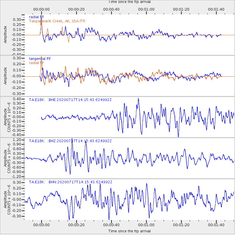
Signal To Noise
| Channel | StoN | STA | LTA |
| TA:E18K: :BHZ:20200717T14:15:43.624992Z | 2.4196084 | 1.18607595E-7 | 4.9019334E-8 |
| TA:E18K: :BHN:20200717T14:15:43.624992Z | 1.087178 | 6.060311E-8 | 5.57435E-8 |
| TA:E18K: :BHE:20200717T14:15:43.624992Z | 1.3669406 | 3.7617855E-8 | 2.7519745E-8 |
| Arrivals |
| Ps | 7.1 SECOND |
| PpPs | 27 SECOND |
| PsPs/PpSs | 34 SECOND |


