You are here: Home > Network List > TA - USArray Transportable Network (new EarthScope stations) Stations List
> Station H16K Elim, AK, USA > Earthquake Result Viewer
H16K Elim, AK, USA - Earthquake Result Viewer
| Earthquake location: |
Andaman Islands, India Region |
| Earthquake latitude/longitude: |
12.0/94.9 |
| Earthquake time(UTC): |
2020/07/17 (199) 14:03:42 GMT |
| Earthquake Depth: |
10 km |
| Earthquake Magnitude: |
6.1 mww |
| Earthquake Catalog/Contributor: |
NEIC PDE/us |
|
| Network: |
TA USArray Transportable Network (new EarthScope stations) |
| Station: |
H16K Elim, AK, USA |
| Lat/Lon: |
64.64 N/162.24 W |
| Elevation: |
216 m |
|
| Distance: |
84.7 deg |
| Az: |
24.94 deg |
| Baz: |
286.667 deg |
| Ray Param: |
0.045297824 |
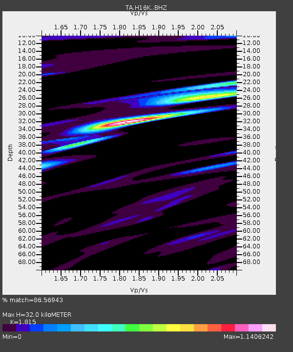
| Estimated Moho Depth: |
32.0 km |
| Estimated Crust Vp/Vs: |
1.82 |
| Assumed Crust Vp: |
6.276 km/s |
| Estimated Crust Vs: |
3.458 km/s |
| Estimated Crust Poisson's Ratio: |
0.28 |
|
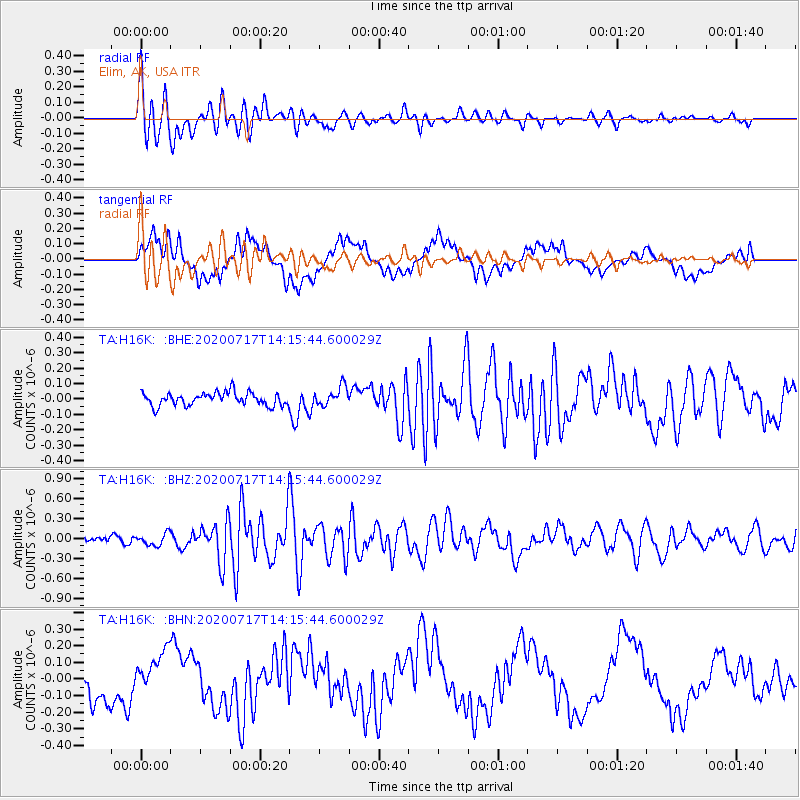
| Radial Match: |
86.56943 % |
| Radial Bump: |
400 |
| Transverse Match: |
44.9046 % |
| Transverse Bump: |
400 |
| SOD ConfigId: |
21709731 |
| Insert Time: |
2020-07-31 14:10:59.747 +0000 |
| GWidth: |
2.5 |
| Max Bumps: |
400 |
| Tol: |
0.001 |
|
Signal To Noise
| Channel | StoN | STA | LTA |
| TA:H16K: :BHZ:20200717T14:15:44.600029Z | 1.8805537 | 8.8522064E-8 | 4.7072337E-8 |
| TA:H16K: :BHN:20200717T14:15:44.600029Z | 1.669584 | 1.2771422E-7 | 7.649463E-8 |
| TA:H16K: :BHE:20200717T14:15:44.600029Z | 1.4604675 | 6.1741446E-8 | 4.2275126E-8 |
| Arrivals |
| Ps | 4.3 SECOND |
| PpPs | 14 SECOND |
| PsPs/PpSs | 18 SECOND |


