You are here: Home > Network List > TA - USArray Transportable Network (new EarthScope stations) Stations List
> Station M22K Willow, AK, USA > Earthquake Result Viewer
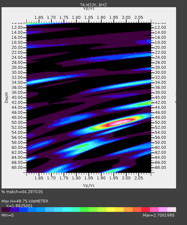
M22K Willow, AK, USA - Earthquake Result Viewer
| Earthquake location: |
Andaman Islands, India Region |
| Earthquake latitude/longitude: |
12.0/94.9 |
| Earthquake time(UTC): |
2020/07/17 (199) 14:03:42 GMT |
| Earthquake Depth: |
10 km |
| Earthquake Magnitude: |
6.1 mww |
| Earthquake Catalog/Contributor: |
NEIC PDE/us |
|
| Network: |
TA USArray Transportable Network (new EarthScope stations) |
| Station: |
M22K Willow, AK, USA |
| Lat/Lon: |
61.75 N/150.12 W |
| Elevation: |
57 m |
|
| Distance: |
90.9 deg |
| Az: |
25.547 deg |
| Baz: |
297.504 deg |
| Ray Param: |
0.04166927 |
| Estimated Moho Depth: |
49.75 km |
| Estimated Crust Vp/Vs: |
1.98 |
| Assumed Crust Vp: |
6.302 km/s |
| Estimated Crust Vs: |
3.179 km/s |
| Estimated Crust Poisson's Ratio: |
0.33 |
|
| Radial Match: |
84.297035 % |
| Radial Bump: |
400 |
| Transverse Match: |
82.18766 % |
| Transverse Bump: |
400 |
| SOD ConfigId: |
21709731 |
| Insert Time: |
2020-07-31 14:11:15.801 +0000 |
| GWidth: |
2.5 |
| Max Bumps: |
400 |
| Tol: |
0.001 |
|

Signal To Noise
| Channel | StoN | STA | LTA |
| TA:M22K: :BHZ:20200717T14:16:14.150017Z | 1.1130291 | 1.0066863E-7 | 9.044564E-8 |
| TA:M22K: :BHN:20200717T14:16:14.150017Z | 0.94929194 | 2.0146996E-7 | 2.1223183E-7 |
| TA:M22K: :BHE:20200717T14:16:14.150017Z | 1.3471326 | 2.1408728E-7 | 1.5892071E-7 |
| Arrivals |
| Ps | 7.9 SECOND |
| PpPs | 23 SECOND |
| PsPs/PpSs | 31 SECOND |


