You are here: Home > Network List > G - GEOSCOPE Stations List
> Station WUS Wushi, Xinjiang Uygur, China > Earthquake Result Viewer
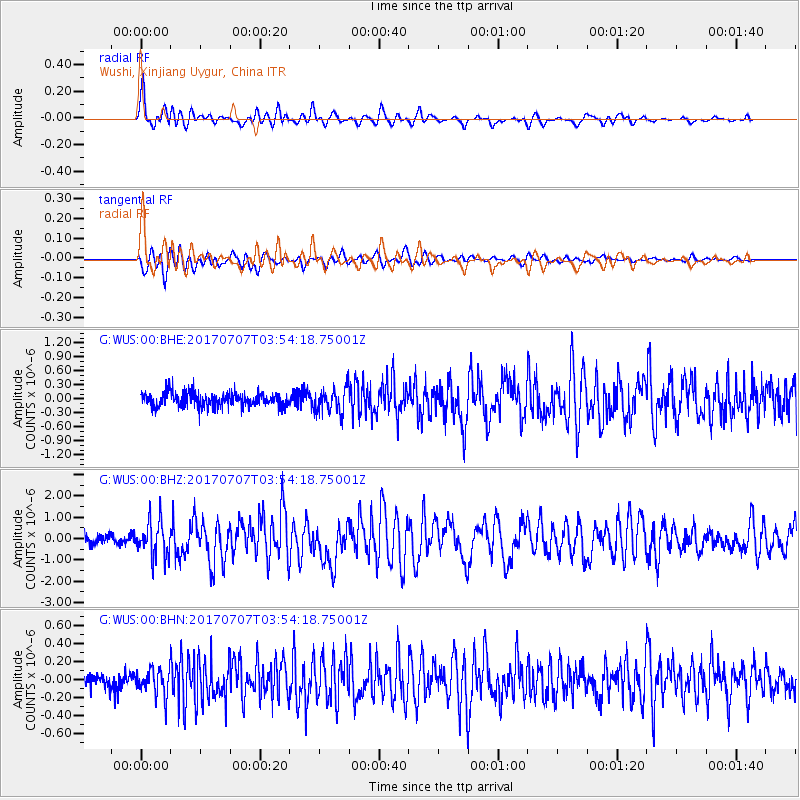
WUS Wushi, Xinjiang Uygur, China - Earthquake Result Viewer
*The percent match for this event was below the threshold and hence no stack was calculated.
| Earthquake location: |
Eastern New Guinea Reg., P.N.G. |
| Earthquake latitude/longitude: |
-6.7/147.8 |
| Earthquake time(UTC): |
2017/07/07 (188) 03:42:52 GMT |
| Earthquake Depth: |
41 km |
| Earthquake Magnitude: |
5.7 Mww |
| Earthquake Catalog/Contributor: |
NEIC PDE/us |
|
| Network: |
G GEOSCOPE |
| Station: |
WUS Wushi, Xinjiang Uygur, China |
| Lat/Lon: |
41.20 N/79.22 E |
| Elevation: |
1457 m |
|
| Distance: |
78.6 deg |
| Az: |
314.229 deg |
| Baz: |
109.425 deg |
| Ray Param: |
$rayparam |
*The percent match for this event was below the threshold and hence was not used in the summary stack. |
|
| Radial Match: |
78.16513 % |
| Radial Bump: |
400 |
| Transverse Match: |
70.88203 % |
| Transverse Bump: |
400 |
| SOD ConfigId: |
2140511 |
| Insert Time: |
2017-07-20 19:35:30.245 +0000 |
| GWidth: |
2.5 |
| Max Bumps: |
400 |
| Tol: |
0.001 |
|
Signal To Noise
| Channel | StoN | STA | LTA |
| G:WUS:00:BHZ:20170707T03:54:18.75001Z | 3.10666 | 8.2928585E-7 | 2.669381E-7 |
| G:WUS:00:BHN:20170707T03:54:18.75001Z | 1.9902912 | 1.385885E-7 | 6.963227E-8 |
| G:WUS:00:BHE:20170707T03:54:18.75001Z | 1.7435541 | 2.669798E-7 | 1.531239E-7 |
| Arrivals |
| Ps | |
| PpPs | |
| PsPs/PpSs | |


