You are here: Home > Network List > TA - USArray Transportable Network (new EarthScope stations) Stations List
> Station E17K Hotham Inlet, AK, USA > Earthquake Result Viewer
E17K Hotham Inlet, AK, USA - Earthquake Result Viewer
| Earthquake location: |
Andaman Islands, India Region |
| Earthquake latitude/longitude: |
12.1/94.9 |
| Earthquake time(UTC): |
2020/07/17 (199) 18:32:59 GMT |
| Earthquake Depth: |
10 km |
| Earthquake Magnitude: |
5.7 mww |
| Earthquake Catalog/Contributor: |
NEIC PDE/us |
|
| Network: |
TA USArray Transportable Network (new EarthScope stations) |
| Station: |
E17K Hotham Inlet, AK, USA |
| Lat/Lon: |
67.08 N/161.83 W |
| Elevation: |
233 m |
|
| Distance: |
84.0 deg |
| Az: |
22.539 deg |
| Baz: |
286.805 deg |
| Ray Param: |
0.04576231 |
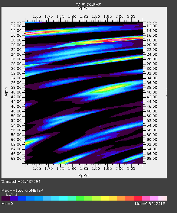
| Estimated Moho Depth: |
15.0 km |
| Estimated Crust Vp/Vs: |
1.60 |
| Assumed Crust Vp: |
6.276 km/s |
| Estimated Crust Vs: |
3.922 km/s |
| Estimated Crust Poisson's Ratio: |
0.18 |
|
| Radial Match: |
91.437294 % |
| Radial Bump: |
355 |
| Transverse Match: |
71.18064 % |
| Transverse Bump: |
400 |
| SOD ConfigId: |
21709731 |
| Insert Time: |
2020-07-31 18:43:04.294 +0000 |
| GWidth: |
2.5 |
| Max Bumps: |
400 |
| Tol: |
0.001 |
|

Signal To Noise
| Channel | StoN | STA | LTA |
| TA:E17K: :BHZ:20200717T18:44:58.699972Z | 7.638521 | 4.8819277E-7 | 6.391195E-8 |
| TA:E17K: :BHN:20200717T18:44:58.699972Z | 1.6527635 | 6.589935E-8 | 3.987222E-8 |
| TA:E17K: :BHE:20200717T18:44:58.699972Z | 3.9534914 | 1.6321934E-7 | 4.128486E-8 |
| Arrivals |
| Ps | 1.5 SECOND |
| PpPs | 6.1 SECOND |
| PsPs/PpSs | 7.5 SECOND |


