You are here: Home > Network List > TA - USArray Transportable Network (new EarthScope stations) Stations List
> Station E20K Nigu River, AK, USA > Earthquake Result Viewer
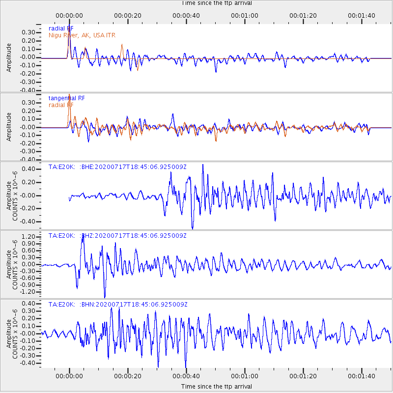
E20K Nigu River, AK, USA - Earthquake Result Viewer
| Earthquake location: |
Andaman Islands, India Region |
| Earthquake latitude/longitude: |
12.1/94.9 |
| Earthquake time(UTC): |
2020/07/17 (199) 18:32:59 GMT |
| Earthquake Depth: |
10 km |
| Earthquake Magnitude: |
5.7 mww |
| Earthquake Catalog/Contributor: |
NEIC PDE/us |
|
| Network: |
TA USArray Transportable Network (new EarthScope stations) |
| Station: |
E20K Nigu River, AK, USA |
| Lat/Lon: |
68.26 N/156.19 W |
| Elevation: |
866 m |
|
| Distance: |
85.7 deg |
| Az: |
20.705 deg |
| Baz: |
291.852 deg |
| Ray Param: |
0.044590913 |
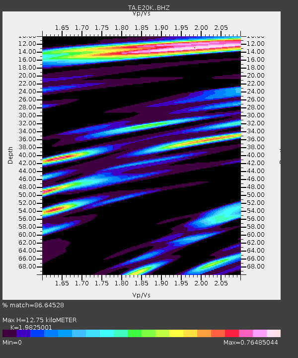
| Estimated Moho Depth: |
12.75 km |
| Estimated Crust Vp/Vs: |
1.98 |
| Assumed Crust Vp: |
6.221 km/s |
| Estimated Crust Vs: |
3.138 km/s |
| Estimated Crust Poisson's Ratio: |
0.33 |
|
| Radial Match: |
86.64528 % |
| Radial Bump: |
400 |
| Transverse Match: |
77.528046 % |
| Transverse Bump: |
400 |
| SOD ConfigId: |
21709731 |
| Insert Time: |
2020-07-31 18:43:07.449 +0000 |
| GWidth: |
2.5 |
| Max Bumps: |
400 |
| Tol: |
0.001 |
|
Signal To Noise
| Channel | StoN | STA | LTA |
| TA:E20K: :BHZ:20200717T18:45:06.925009Z | 11.38235 | 5.576579E-7 | 4.899322E-8 |
| TA:E20K: :BHN:20200717T18:45:06.925009Z | 1.8418458 | 8.4014516E-8 | 4.5614303E-8 |
| TA:E20K: :BHE:20200717T18:45:06.925009Z | 4.8504915 | 1.431946E-7 | 2.9521667E-8 |
| Arrivals |
| Ps | 2.1 SECOND |
| PpPs | 6.0 SECOND |
| PsPs/PpSs | 8.0 SECOND |


