You are here: Home > Network List > TA - USArray Transportable Network (new EarthScope stations) Stations List
> Station E21K Killik River, AK, USA > Earthquake Result Viewer
E21K Killik River, AK, USA - Earthquake Result Viewer
| Earthquake location: |
Andaman Islands, India Region |
| Earthquake latitude/longitude: |
12.1/94.9 |
| Earthquake time(UTC): |
2020/07/17 (199) 18:32:59 GMT |
| Earthquake Depth: |
10 km |
| Earthquake Magnitude: |
5.7 mww |
| Earthquake Catalog/Contributor: |
NEIC PDE/us |
|
| Network: |
TA USArray Transportable Network (new EarthScope stations) |
| Station: |
E21K Killik River, AK, USA |
| Lat/Lon: |
68.44 N/153.97 W |
| Elevation: |
653 m |
|
| Distance: |
86.4 deg |
| Az: |
20.214 deg |
| Baz: |
293.876 deg |
| Ray Param: |
0.044103917 |
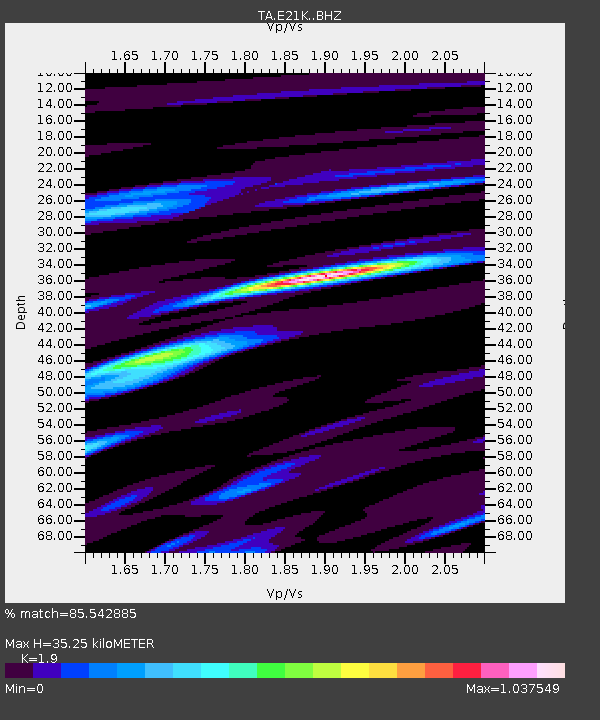
| Estimated Moho Depth: |
35.25 km |
| Estimated Crust Vp/Vs: |
1.90 |
| Assumed Crust Vp: |
6.221 km/s |
| Estimated Crust Vs: |
3.274 km/s |
| Estimated Crust Poisson's Ratio: |
0.31 |
|
| Radial Match: |
85.542885 % |
| Radial Bump: |
400 |
| Transverse Match: |
80.378395 % |
| Transverse Bump: |
400 |
| SOD ConfigId: |
21709731 |
| Insert Time: |
2020-07-31 18:43:10.305 +0000 |
| GWidth: |
2.5 |
| Max Bumps: |
400 |
| Tol: |
0.001 |
|

Signal To Noise
| Channel | StoN | STA | LTA |
| TA:E21K: :BHZ:20200717T18:45:10.324972Z | 15.659181 | 5.8023176E-7 | 3.7053773E-8 |
| TA:E21K: :BHN:20200717T18:45:10.324972Z | 1.1659478 | 5.3684104E-8 | 4.604332E-8 |
| TA:E21K: :BHE:20200717T18:45:10.324972Z | 4.5176516 | 2.0889219E-7 | 4.6239112E-8 |
| Arrivals |
| Ps | 5.2 SECOND |
| PpPs | 16 SECOND |
| PsPs/PpSs | 21 SECOND |


