You are here: Home > Network List > TA - USArray Transportable Network (new EarthScope stations) Stations List
> Station F20K Avaraart Lake, AK, USA > Earthquake Result Viewer
F20K Avaraart Lake, AK, USA - Earthquake Result Viewer

| Earthquake location: |
Andaman Islands, India Region |
| Earthquake latitude/longitude: |
12.1/94.9 |
| Earthquake time(UTC): |
2020/07/17 (199) 18:32:59 GMT |
| Earthquake Depth: |
10 km |
| Earthquake Magnitude: |
5.7 mww |
| Earthquake Catalog/Contributor: |
NEIC PDE/us |
|
| Network: |
TA USArray Transportable Network (new EarthScope stations) |
| Station: |
F20K Avaraart Lake, AK, USA |
| Lat/Lon: |
67.05 N/155.73 W |
| Elevation: |
136 m |
|
| Distance: |
86.3 deg |
| Az: |
21.767 deg |
| Baz: |
292.354 deg |
| Ray Param: |
0.044150904 |
| Estimated Moho Depth: |
24.0 km |
| Estimated Crust Vp/Vs: |
1.79 |
| Assumed Crust Vp: |
6.522 km/s |
| Estimated Crust Vs: |
3.643 km/s |
| Estimated Crust Poisson's Ratio: |
0.27 |
|
| Radial Match: |
91.50415 % |
| Radial Bump: |
400 |
| Transverse Match: |
82.6543 % |
| Transverse Bump: |
400 |
| SOD ConfigId: |
21709731 |
| Insert Time: |
2020-07-31 18:43:30.455 +0000 |
| GWidth: |
2.5 |
| Max Bumps: |
400 |
| Tol: |
0.001 |
|
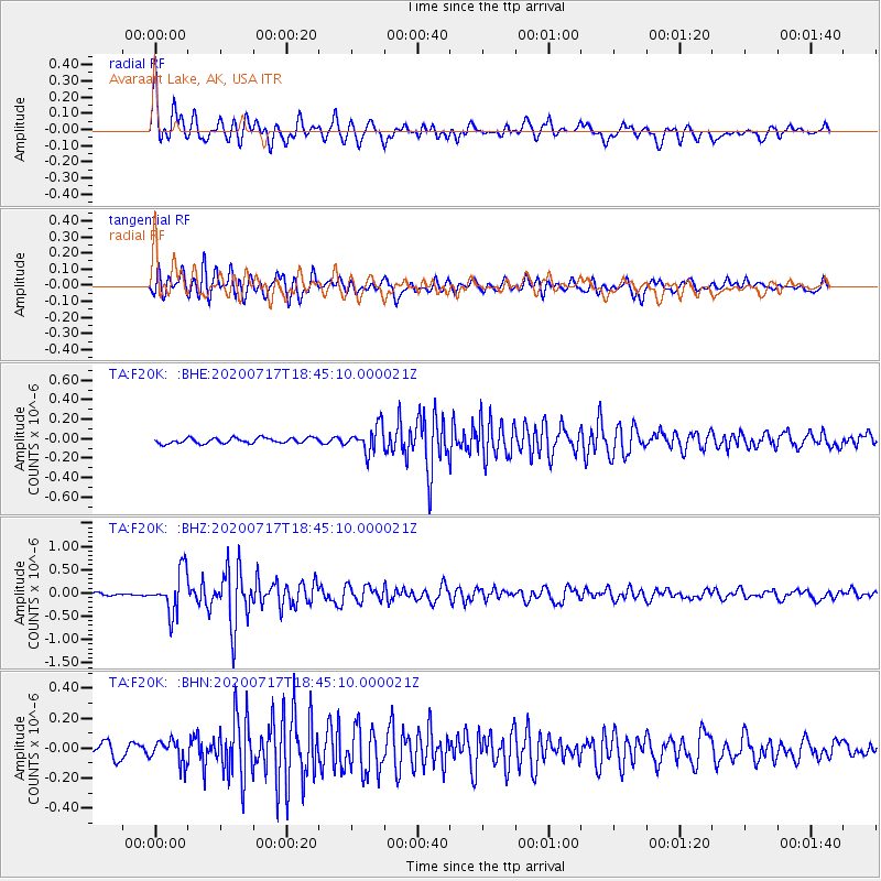
Signal To Noise
| Channel | StoN | STA | LTA |
| TA:F20K: :BHZ:20200717T18:45:10.000021Z | 13.881894 | 4.4998382E-7 | 3.241516E-8 |
| TA:F20K: :BHN:20200717T18:45:10.000021Z | 1.7654767 | 7.573608E-8 | 4.2898375E-8 |
| TA:F20K: :BHE:20200717T18:45:10.000021Z | 4.773868 | 1.3332857E-7 | 2.7928836E-8 |
| Arrivals |
| Ps | 3.0 SECOND |
| PpPs | 10 SECOND |
| PsPs/PpSs | 13 SECOND |


