You are here: Home > Network List > AV - Alaska Volcano Observatory Stations List
> Station KINC North Cape, Kanaga Volcano, Alaska > Earthquake Result Viewer
KINC North Cape, Kanaga Volcano, Alaska - Earthquake Result Viewer
| Earthquake location: |
Solomon Islands |
| Earthquake latitude/longitude: |
-10.4/161.4 |
| Earthquake time(UTC): |
2020/07/18 (200) 01:37:14 GMT |
| Earthquake Depth: |
42 km |
| Earthquake Magnitude: |
5.9 Mww |
| Earthquake Catalog/Contributor: |
NEIC PDE/us |
|
| Network: |
AV Alaska Volcano Observatory |
| Station: |
KINC North Cape, Kanaga Volcano, Alaska |
| Lat/Lon: |
51.93 N/177.13 W |
| Elevation: |
198 m |
|
| Distance: |
64.8 deg |
| Az: |
14.506 deg |
| Baz: |
203.452 deg |
| Ray Param: |
0.058632433 |
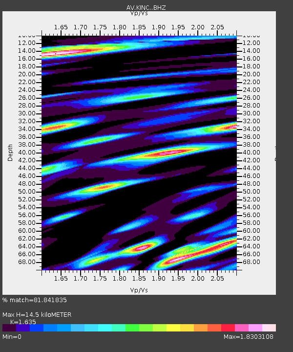
| Estimated Moho Depth: |
14.5 km |
| Estimated Crust Vp/Vs: |
1.63 |
| Assumed Crust Vp: |
5.88 km/s |
| Estimated Crust Vs: |
3.597 km/s |
| Estimated Crust Poisson's Ratio: |
0.20 |
|
| Radial Match: |
81.841835 % |
| Radial Bump: |
400 |
| Transverse Match: |
76.88741 % |
| Transverse Bump: |
400 |
| SOD ConfigId: |
21709731 |
| Insert Time: |
2020-08-01 01:42:53.407 +0000 |
| GWidth: |
2.5 |
| Max Bumps: |
400 |
| Tol: |
0.001 |
|

Signal To Noise
| Channel | StoN | STA | LTA |
| AV:KINC: :BHZ:20200718T01:47:18.240028Z | 10.413975 | 1.3186066E-6 | 1.2661894E-7 |
| AV:KINC: :BHN:20200718T01:47:18.240028Z | 2.8023703 | 8.3454626E-7 | 2.9780014E-7 |
| AV:KINC: :BHE:20200718T01:47:18.240028Z | 3.6340172 | 1.0038386E-6 | 2.762339E-7 |
| Arrivals |
| Ps | 1.6 SECOND |
| PpPs | 6.3 SECOND |
| PsPs/PpSs | 7.9 SECOND |


