You are here: Home > Network List > AV - Alaska Volcano Observatory Stations List
> Station MAPS Pakushin Southeast, Makushin Volcano, Alaska > Earthquake Result Viewer
MAPS Pakushin Southeast, Makushin Volcano, Alaska - Earthquake Result Viewer
*The percent match for this event was below the threshold and hence no stack was calculated.
| Earthquake location: |
Solomon Islands |
| Earthquake latitude/longitude: |
-10.4/161.4 |
| Earthquake time(UTC): |
2020/07/18 (200) 01:37:14 GMT |
| Earthquake Depth: |
42 km |
| Earthquake Magnitude: |
5.9 Mww |
| Earthquake Catalog/Contributor: |
NEIC PDE/us |
|
| Network: |
AV Alaska Volcano Observatory |
| Station: |
MAPS Pakushin Southeast, Makushin Volcano, Alaska |
| Lat/Lon: |
53.81 N/166.94 W |
| Elevation: |
333 m |
|
| Distance: |
69.4 deg |
| Az: |
19.425 deg |
| Baz: |
213.484 deg |
| Ray Param: |
$rayparam |
*The percent match for this event was below the threshold and hence was not used in the summary stack. |
|
| Radial Match: |
69.008575 % |
| Radial Bump: |
400 |
| Transverse Match: |
63.92851 % |
| Transverse Bump: |
400 |
| SOD ConfigId: |
21709731 |
| Insert Time: |
2020-08-01 01:43:08.577 +0000 |
| GWidth: |
2.5 |
| Max Bumps: |
400 |
| Tol: |
0.001 |
|
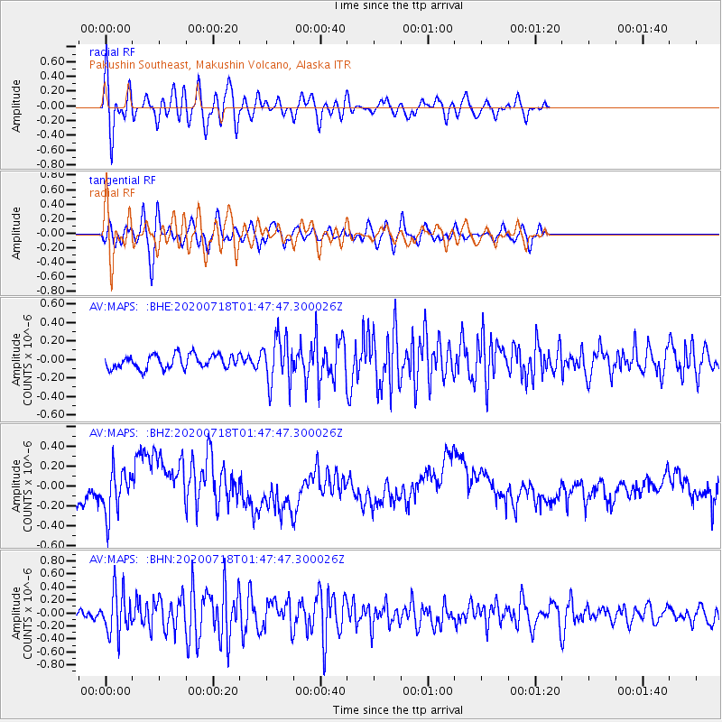
Signal To Noise
| Channel | StoN | STA | LTA |
| AV:MAPS: :BHZ:20200718T01:47:47.300026Z | 2.0176337 | 2.1997111E-7 | 1.0902431E-7 |
| AV:MAPS: :BHN:20200718T01:47:47.300026Z | 4.55595 | 3.232482E-7 | 7.095078E-8 |
| AV:MAPS: :BHE:20200718T01:47:47.300026Z | 3.4142687 | 2.5282372E-7 | 7.4049154E-8 |
| Arrivals |
| Ps | |
| PpPs | |
| PsPs/PpSs | |


