You are here: Home > Network List > AV - Alaska Volcano Observatory Stations List
> Station SPCR Ckakachatna River, Mount Spurr, Alaska > Earthquake Result Viewer
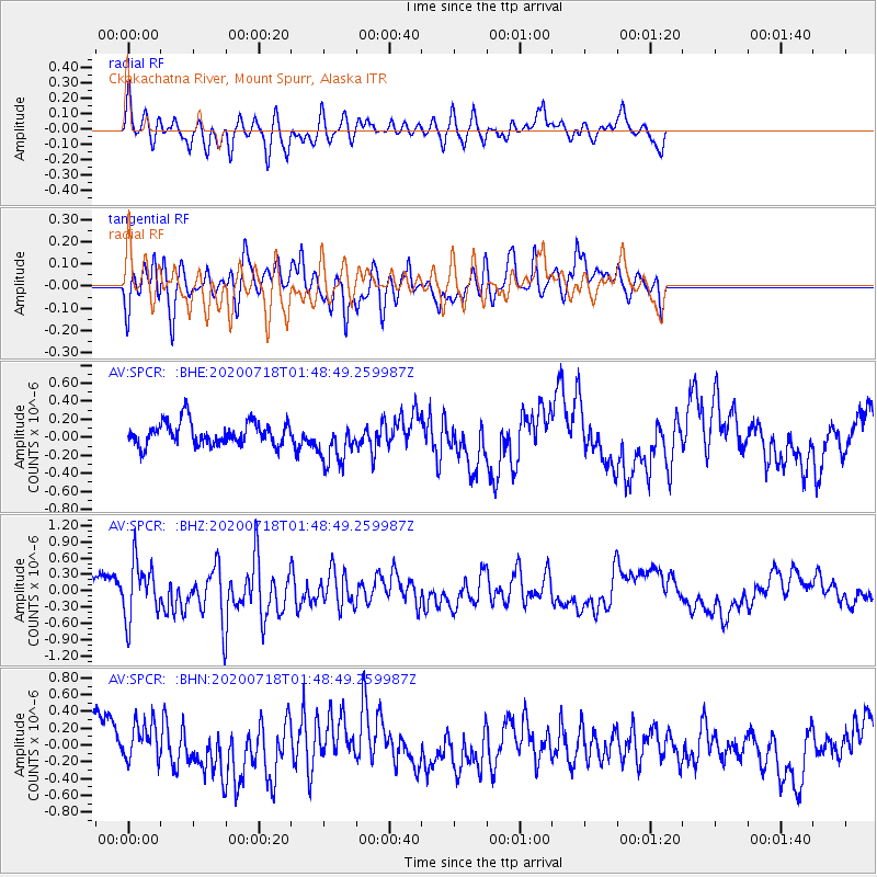
SPCR Ckakachatna River, Mount Spurr, Alaska - Earthquake Result Viewer
*The percent match for this event was below the threshold and hence no stack was calculated.
| Earthquake location: |
Solomon Islands |
| Earthquake latitude/longitude: |
-10.4/161.4 |
| Earthquake time(UTC): |
2020/07/18 (200) 01:37:14 GMT |
| Earthquake Depth: |
42 km |
| Earthquake Magnitude: |
5.9 Mww |
| Earthquake Catalog/Contributor: |
NEIC PDE/us |
|
| Network: |
AV Alaska Volcano Observatory |
| Station: |
SPCR Ckakachatna River, Mount Spurr, Alaska |
| Lat/Lon: |
61.20 N/152.21 W |
| Elevation: |
984 m |
|
| Distance: |
80.1 deg |
| Az: |
20.848 deg |
| Baz: |
226.307 deg |
| Ray Param: |
$rayparam |
*The percent match for this event was below the threshold and hence was not used in the summary stack. |
|
| Radial Match: |
55.15868 % |
| Radial Bump: |
361 |
| Transverse Match: |
64.79047 % |
| Transverse Bump: |
400 |
| SOD ConfigId: |
21709731 |
| Insert Time: |
2020-08-01 01:43:38.210 +0000 |
| GWidth: |
2.5 |
| Max Bumps: |
400 |
| Tol: |
0.001 |
|
Signal To Noise
| Channel | StoN | STA | LTA |
| AV:SPCR: :BHZ:20200718T01:48:49.259987Z | 2.5779672 | 5.198375E-7 | 2.0164627E-7 |
| AV:SPCR: :BHN:20200718T01:48:49.259987Z | 1.2975686 | 2.4561916E-7 | 1.8929185E-7 |
| AV:SPCR: :BHE:20200718T01:48:49.259987Z | 1.9194846 | 2.4680804E-7 | 1.2858037E-7 |
| Arrivals |
| Ps | |
| PpPs | |
| PsPs/PpSs | |


