You are here: Home > Network List > XD94 - Tanzania BB Experiment Stations List
> Station MTOR XD.MTOR > Earthquake Result Viewer
MTOR XD.MTOR - Earthquake Result Viewer
| Earthquake location: |
Myanmar |
| Earthquake latitude/longitude: |
24.7/95.2 |
| Earthquake time(UTC): |
1994/08/08 (220) 21:08:31 GMT |
| Earthquake Depth: |
127 km |
| Earthquake Magnitude: |
6.0 MB, 5.1 UNKNOWN, 6.1 MW |
| Earthquake Catalog/Contributor: |
WHDF/NEIC |
|
| Network: |
XD Tanzania BB Experiment |
| Station: |
MTOR XD.MTOR |
| Lat/Lon: |
5.25 S/35.40 E |
| Elevation: |
1100 m |
|
| Distance: |
65.3 deg |
| Az: |
251.333 deg |
| Baz: |
59.904 deg |
| Ray Param: |
0.05799377 |
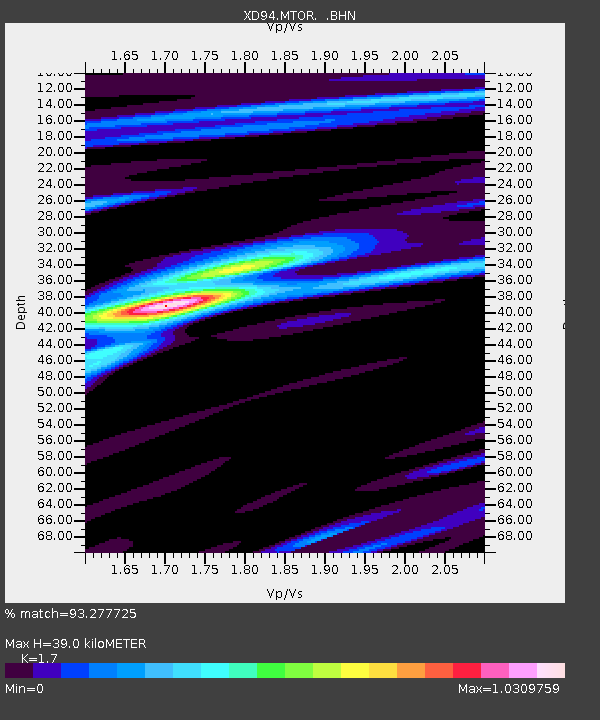
| Estimated Moho Depth: |
39.0 km |
| Estimated Crust Vp/Vs: |
1.70 |
| Assumed Crust Vp: |
6.601 km/s |
| Estimated Crust Vs: |
3.883 km/s |
| Estimated Crust Poisson's Ratio: |
0.24 |
|
| Radial Match: |
93.277725 % |
| Radial Bump: |
312 |
| Transverse Match: |
82.871086 % |
| Transverse Bump: |
394 |
| SOD ConfigId: |
16938 |
| Insert Time: |
2010-03-08 22:53:27.212 +0000 |
| GWidth: |
2.5 |
| Max Bumps: |
400 |
| Tol: |
0.001 |
|

Signal To Noise
| Channel | StoN | STA | LTA |
| XD:MTOR: :BHN:19940808T21:18:29.655005Z | 5.0223975 | 362.0199 | 72.08109 |
| XD:MTOR: :BHE:19940808T21:18:29.655005Z | 9.84853 | 900.0219 | 91.38642 |
| XD:MTOR: :BHZ:19940808T21:18:29.655005Z | 33.65489 | 2048.287 | 60.8615 |
| Arrivals |
| Ps | 4.3 SECOND |
| PpPs | 15 SECOND |
| PsPs/PpSs | 20 SECOND |


