You are here: Home > Network List > TA - USArray Transportable Network (new EarthScope stations) Stations List
> Station D25K Kavik River, AK, USA > Earthquake Result Viewer
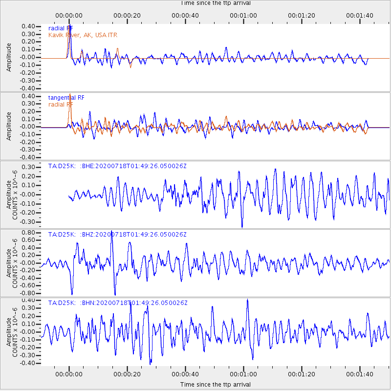
D25K Kavik River, AK, USA - Earthquake Result Viewer
*The percent match for this event was below the threshold and hence no stack was calculated.
| Earthquake location: |
Solomon Islands |
| Earthquake latitude/longitude: |
-10.4/161.4 |
| Earthquake time(UTC): |
2020/07/18 (200) 01:37:14 GMT |
| Earthquake Depth: |
42 km |
| Earthquake Magnitude: |
5.9 Mww |
| Earthquake Catalog/Contributor: |
NEIC PDE/us |
|
| Network: |
TA USArray Transportable Network (new EarthScope stations) |
| Station: |
D25K Kavik River, AK, USA |
| Lat/Lon: |
69.32 N/146.38 W |
| Elevation: |
770 m |
|
| Distance: |
87.3 deg |
| Az: |
16.322 deg |
| Baz: |
231.117 deg |
| Ray Param: |
$rayparam |
*The percent match for this event was below the threshold and hence was not used in the summary stack. |
|
| Radial Match: |
79.410164 % |
| Radial Bump: |
400 |
| Transverse Match: |
66.90502 % |
| Transverse Bump: |
400 |
| SOD ConfigId: |
21709731 |
| Insert Time: |
2020-08-01 01:54:01.158 +0000 |
| GWidth: |
2.5 |
| Max Bumps: |
400 |
| Tol: |
0.001 |
|
Signal To Noise
| Channel | StoN | STA | LTA |
| TA:D25K: :BHZ:20200718T01:49:26.050026Z | 6.068517 | 3.4639297E-7 | 5.708033E-8 |
| TA:D25K: :BHN:20200718T01:49:26.050026Z | 2.2702577 | 1.2527296E-7 | 5.5180067E-8 |
| TA:D25K: :BHE:20200718T01:49:26.050026Z | 1.2185533 | 8.257436E-8 | 6.7764255E-8 |
| Arrivals |
| Ps | |
| PpPs | |
| PsPs/PpSs | |


