You are here: Home > Network List > TA - USArray Transportable Network (new EarthScope stations) Stations List
> Station E18K Tukpahlearik Creek, AK, USA > Earthquake Result Viewer
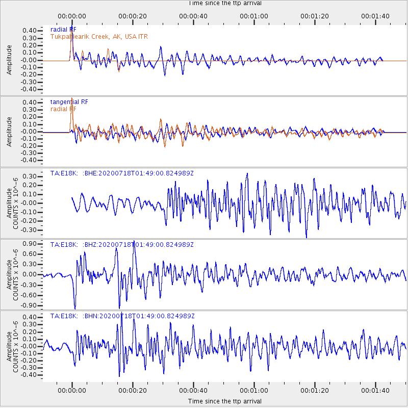
E18K Tukpahlearik Creek, AK, USA - Earthquake Result Viewer
*The percent match for this event was below the threshold and hence no stack was calculated.
| Earthquake location: |
Solomon Islands |
| Earthquake latitude/longitude: |
-10.4/161.4 |
| Earthquake time(UTC): |
2020/07/18 (200) 01:37:14 GMT |
| Earthquake Depth: |
42 km |
| Earthquake Magnitude: |
5.9 Mww |
| Earthquake Catalog/Contributor: |
NEIC PDE/us |
|
| Network: |
TA USArray Transportable Network (new EarthScope stations) |
| Station: |
E18K Tukpahlearik Creek, AK, USA |
| Lat/Lon: |
67.42 N/160.60 W |
| Elevation: |
297 m |
|
| Distance: |
82.3 deg |
| Az: |
13.879 deg |
| Baz: |
217.671 deg |
| Ray Param: |
$rayparam |
*The percent match for this event was below the threshold and hence was not used in the summary stack. |
|
| Radial Match: |
79.3972 % |
| Radial Bump: |
400 |
| Transverse Match: |
76.49161 % |
| Transverse Bump: |
400 |
| SOD ConfigId: |
21709731 |
| Insert Time: |
2020-08-01 01:54:05.756 +0000 |
| GWidth: |
2.5 |
| Max Bumps: |
400 |
| Tol: |
0.001 |
|
Signal To Noise
| Channel | StoN | STA | LTA |
| TA:E18K: :BHZ:20200718T01:49:00.824989Z | 8.733619 | 4.166444E-7 | 4.7705818E-8 |
| TA:E18K: :BHN:20200718T01:49:00.824989Z | 1.7641944 | 1.30335E-7 | 7.387791E-8 |
| TA:E18K: :BHE:20200718T01:49:00.824989Z | 2.2118745 | 1.2288942E-7 | 5.5558946E-8 |
| Arrivals |
| Ps | |
| PpPs | |
| PsPs/PpSs | |


