You are here: Home > Network List > TA - USArray Transportable Network (new EarthScope stations) Stations List
> Station E19K Redstone River, AK, USA > Earthquake Result Viewer
E19K Redstone River, AK, USA - Earthquake Result Viewer
| Earthquake location: |
Solomon Islands |
| Earthquake latitude/longitude: |
-10.4/161.4 |
| Earthquake time(UTC): |
2020/07/18 (200) 01:37:14 GMT |
| Earthquake Depth: |
42 km |
| Earthquake Magnitude: |
5.9 Mww |
| Earthquake Catalog/Contributor: |
NEIC PDE/us |
|
| Network: |
TA USArray Transportable Network (new EarthScope stations) |
| Station: |
E19K Redstone River, AK, USA |
| Lat/Lon: |
67.46 N/157.23 W |
| Elevation: |
441 m |
|
| Distance: |
83.1 deg |
| Az: |
14.87 deg |
| Baz: |
220.906 deg |
| Ray Param: |
0.04633367 |
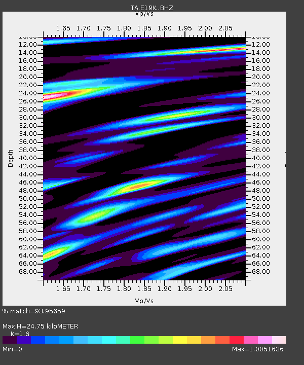
| Estimated Moho Depth: |
24.75 km |
| Estimated Crust Vp/Vs: |
1.60 |
| Assumed Crust Vp: |
6.577 km/s |
| Estimated Crust Vs: |
4.11 km/s |
| Estimated Crust Poisson's Ratio: |
0.18 |
|
| Radial Match: |
93.95659 % |
| Radial Bump: |
400 |
| Transverse Match: |
89.92458 % |
| Transverse Bump: |
400 |
| SOD ConfigId: |
21709731 |
| Insert Time: |
2020-08-01 01:54:07.278 +0000 |
| GWidth: |
2.5 |
| Max Bumps: |
400 |
| Tol: |
0.001 |
|

Signal To Noise
| Channel | StoN | STA | LTA |
| TA:E19K: :BHZ:20200718T01:49:05.225014Z | 12.107769 | 6.8235187E-7 | 5.635653E-8 |
| TA:E19K: :BHN:20200718T01:49:05.225014Z | 3.978732 | 1.8059902E-7 | 4.5391097E-8 |
| TA:E19K: :BHE:20200718T01:49:05.225014Z | 4.8670235 | 1.9221989E-7 | 3.9494342E-8 |
| Arrivals |
| Ps | 2.3 SECOND |
| PpPs | 9.5 SECOND |
| PsPs/PpSs | 12 SECOND |


