You are here: Home > Network List > TA - USArray Transportable Network (new EarthScope stations) Stations List
> Station E20K Nigu River, AK, USA > Earthquake Result Viewer
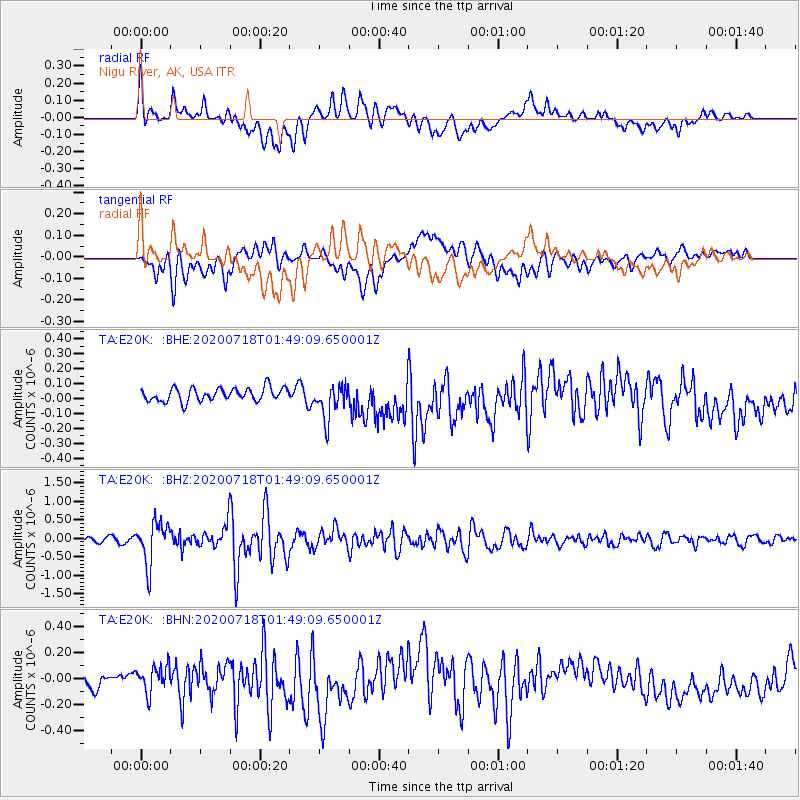
E20K Nigu River, AK, USA - Earthquake Result Viewer
*The percent match for this event was below the threshold and hence no stack was calculated.
| Earthquake location: |
Solomon Islands |
| Earthquake latitude/longitude: |
-10.4/161.4 |
| Earthquake time(UTC): |
2020/07/18 (200) 01:37:14 GMT |
| Earthquake Depth: |
42 km |
| Earthquake Magnitude: |
5.9 Mww |
| Earthquake Catalog/Contributor: |
NEIC PDE/us |
|
| Network: |
TA USArray Transportable Network (new EarthScope stations) |
| Station: |
E20K Nigu River, AK, USA |
| Lat/Lon: |
68.26 N/156.19 W |
| Elevation: |
866 m |
|
| Distance: |
84.0 deg |
| Az: |
14.634 deg |
| Baz: |
221.845 deg |
| Ray Param: |
$rayparam |
*The percent match for this event was below the threshold and hence was not used in the summary stack. |
|
| Radial Match: |
73.76035 % |
| Radial Bump: |
400 |
| Transverse Match: |
70.371254 % |
| Transverse Bump: |
400 |
| SOD ConfigId: |
21709731 |
| Insert Time: |
2020-08-01 01:54:08.415 +0000 |
| GWidth: |
2.5 |
| Max Bumps: |
400 |
| Tol: |
0.001 |
|
Signal To Noise
| Channel | StoN | STA | LTA |
| TA:E20K: :BHZ:20200718T01:49:09.650001Z | 9.815427 | 5.697521E-7 | 5.804659E-8 |
| TA:E20K: :BHN:20200718T01:49:09.650001Z | 2.1618128 | 1.06745006E-7 | 4.9377544E-8 |
| TA:E20K: :BHE:20200718T01:49:09.650001Z | 2.6404817 | 1.1692182E-7 | 4.428049E-8 |
| Arrivals |
| Ps | |
| PpPs | |
| PsPs/PpSs | |


