You are here: Home > Network List > TA - USArray Transportable Network (new EarthScope stations) Stations List
> Station F25K Christian River, AK, USA > Earthquake Result Viewer
F25K Christian River, AK, USA - Earthquake Result Viewer
| Earthquake location: |
Solomon Islands |
| Earthquake latitude/longitude: |
-10.4/161.4 |
| Earthquake time(UTC): |
2020/07/18 (200) 01:37:14 GMT |
| Earthquake Depth: |
42 km |
| Earthquake Magnitude: |
5.9 Mww |
| Earthquake Catalog/Contributor: |
NEIC PDE/us |
|
| Network: |
TA USArray Transportable Network (new EarthScope stations) |
| Station: |
F25K Christian River, AK, USA |
| Lat/Lon: |
67.59 N/145.64 W |
| Elevation: |
864 m |
|
| Distance: |
86.5 deg |
| Az: |
17.852 deg |
| Baz: |
231.88 deg |
| Ray Param: |
0.04397515 |
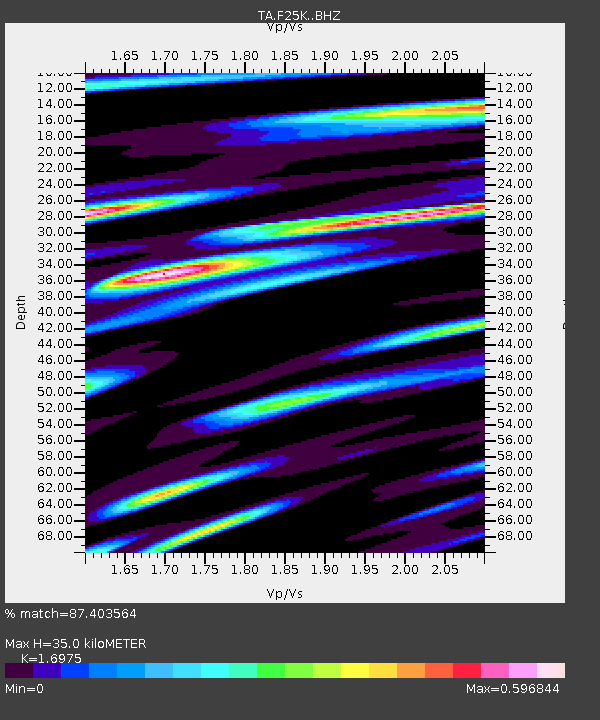
| Estimated Moho Depth: |
35.0 km |
| Estimated Crust Vp/Vs: |
1.70 |
| Assumed Crust Vp: |
6.522 km/s |
| Estimated Crust Vs: |
3.842 km/s |
| Estimated Crust Poisson's Ratio: |
0.23 |
|
| Radial Match: |
87.403564 % |
| Radial Bump: |
400 |
| Transverse Match: |
88.77508 % |
| Transverse Bump: |
336 |
| SOD ConfigId: |
21709731 |
| Insert Time: |
2020-08-01 01:54:34.838 +0000 |
| GWidth: |
2.5 |
| Max Bumps: |
400 |
| Tol: |
0.001 |
|

Signal To Noise
| Channel | StoN | STA | LTA |
| TA:F25K: :BHZ:20200718T01:49:21.850014Z | 12.316148 | 5.862586E-7 | 4.7600807E-8 |
| TA:F25K: :BHN:20200718T01:49:21.850014Z | 4.445612 | 1.1944826E-7 | 2.6868802E-8 |
| TA:F25K: :BHE:20200718T01:49:21.850014Z | 6.0302763 | 2.0815848E-7 | 3.4518898E-8 |
| Arrivals |
| Ps | 3.8 SECOND |
| PpPs | 14 SECOND |
| PsPs/PpSs | 18 SECOND |


