You are here: Home > Network List > TA - USArray Transportable Network (new EarthScope stations) Stations List
> Station G17K Kiwalik Mountain, AK, USA > Earthquake Result Viewer
G17K Kiwalik Mountain, AK, USA - Earthquake Result Viewer
| Earthquake location: |
Solomon Islands |
| Earthquake latitude/longitude: |
-10.4/161.4 |
| Earthquake time(UTC): |
2020/07/18 (200) 01:37:14 GMT |
| Earthquake Depth: |
42 km |
| Earthquake Magnitude: |
5.9 Mww |
| Earthquake Catalog/Contributor: |
NEIC PDE/us |
|
| Network: |
TA USArray Transportable Network (new EarthScope stations) |
| Station: |
G17K Kiwalik Mountain, AK, USA |
| Lat/Lon: |
65.50 N/160.65 W |
| Elevation: |
338 m |
|
| Distance: |
80.8 deg |
| Az: |
15.057 deg |
| Baz: |
217.8 deg |
| Ray Param: |
0.047997486 |
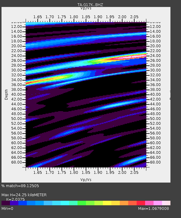
| Estimated Moho Depth: |
24.25 km |
| Estimated Crust Vp/Vs: |
2.04 |
| Assumed Crust Vp: |
6.276 km/s |
| Estimated Crust Vs: |
3.08 km/s |
| Estimated Crust Poisson's Ratio: |
0.34 |
|
| Radial Match: |
89.12505 % |
| Radial Bump: |
400 |
| Transverse Match: |
86.01836 % |
| Transverse Bump: |
400 |
| SOD ConfigId: |
21709731 |
| Insert Time: |
2020-08-01 01:54:49.963 +0000 |
| GWidth: |
2.5 |
| Max Bumps: |
400 |
| Tol: |
0.001 |
|

Signal To Noise
| Channel | StoN | STA | LTA |
| TA:G17K: :BHZ:20200718T01:48:52.725014Z | 10.286964 | 5.612652E-7 | 5.4560818E-8 |
| TA:G17K: :BHN:20200718T01:48:52.725014Z | 3.1275187 | 1.2674079E-7 | 4.052439E-8 |
| TA:G17K: :BHE:20200718T01:48:52.725014Z | 3.6747534 | 1.8471682E-7 | 5.0266454E-8 |
| Arrivals |
| Ps | 4.1 SECOND |
| PpPs | 11 SECOND |
| PsPs/PpSs | 16 SECOND |


