You are here: Home > Network List > TA - USArray Transportable Network (new EarthScope stations) Stations List
> Station G29M Pine Creek, YT, CAN > Earthquake Result Viewer
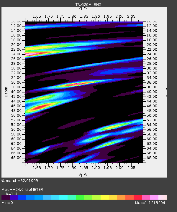
G29M Pine Creek, YT, CAN - Earthquake Result Viewer
| Earthquake location: |
Solomon Islands |
| Earthquake latitude/longitude: |
-10.4/161.4 |
| Earthquake time(UTC): |
2020/07/18 (200) 01:37:14 GMT |
| Earthquake Depth: |
42 km |
| Earthquake Magnitude: |
5.9 Mww |
| Earthquake Catalog/Contributor: |
NEIC PDE/us |
|
| Network: |
TA USArray Transportable Network (new EarthScope stations) |
| Station: |
G29M Pine Creek, YT, CAN |
| Lat/Lon: |
66.91 N/138.02 W |
| Elevation: |
572 m |
|
| Distance: |
88.5 deg |
| Az: |
20.097 deg |
| Baz: |
239.001 deg |
| Ray Param: |
0.042470288 |
| Estimated Moho Depth: |
24.0 km |
| Estimated Crust Vp/Vs: |
1.60 |
| Assumed Crust Vp: |
6.577 km/s |
| Estimated Crust Vs: |
4.11 km/s |
| Estimated Crust Poisson's Ratio: |
0.18 |
|
| Radial Match: |
82.01009 % |
| Radial Bump: |
400 |
| Transverse Match: |
74.08911 % |
| Transverse Bump: |
400 |
| SOD ConfigId: |
21709731 |
| Insert Time: |
2020-08-01 01:55:01.458 +0000 |
| GWidth: |
2.5 |
| Max Bumps: |
400 |
| Tol: |
0.001 |
|

Signal To Noise
| Channel | StoN | STA | LTA |
| TA:G29M: :BHZ:20200718T01:49:31.675026Z | 7.992717 | 7.125241E-7 | 8.9146674E-8 |
| TA:G29M: :BHN:20200718T01:49:31.675026Z | 1.7438679 | 1.5495029E-7 | 8.885438E-8 |
| TA:G29M: :BHE:20200718T01:49:31.675026Z | 1.6266284 | 1.307502E-7 | 8.0381106E-8 |
| Arrivals |
| Ps | 2.2 SECOND |
| PpPs | 9.3 SECOND |
| PsPs/PpSs | 11 SECOND |


