You are here: Home > Network List > TA - USArray Transportable Network (new EarthScope stations) Stations List
> Station I30M Mount Dempster, Yukon, CAN > Earthquake Result Viewer
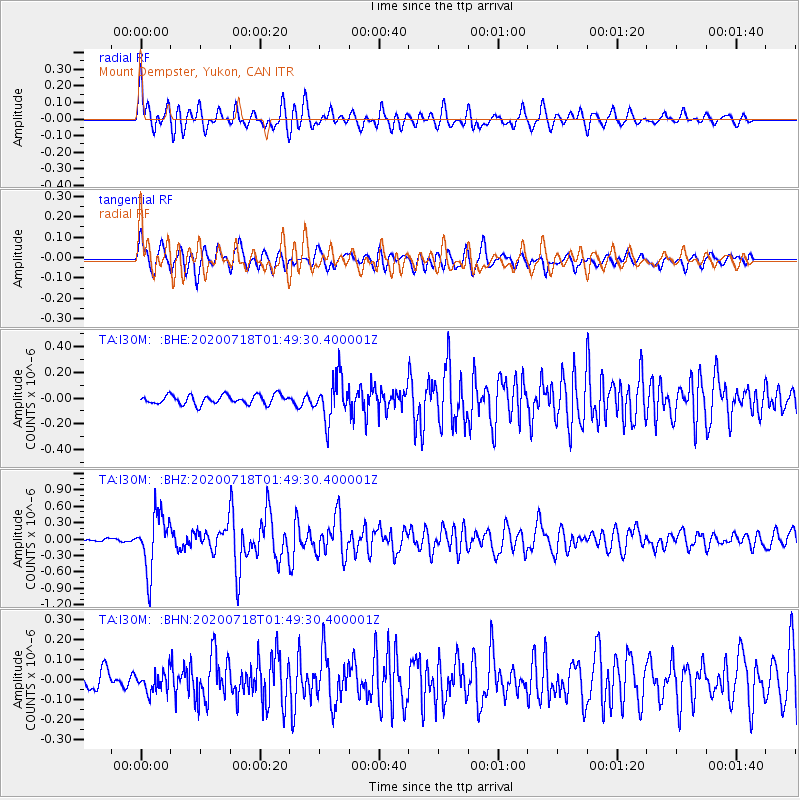
I30M Mount Dempster, Yukon, CAN - Earthquake Result Viewer
*The percent match for this event was below the threshold and hence no stack was calculated.
| Earthquake location: |
Solomon Islands |
| Earthquake latitude/longitude: |
-10.4/161.4 |
| Earthquake time(UTC): |
2020/07/18 (200) 01:37:14 GMT |
| Earthquake Depth: |
42 km |
| Earthquake Magnitude: |
5.9 Mww |
| Earthquake Catalog/Contributor: |
NEIC PDE/us |
|
| Network: |
TA USArray Transportable Network (new EarthScope stations) |
| Station: |
I30M Mount Dempster, Yukon, CAN |
| Lat/Lon: |
65.22 N/136.38 W |
| Elevation: |
1399 m |
|
| Distance: |
88.2 deg |
| Az: |
21.902 deg |
| Baz: |
240.555 deg |
| Ray Param: |
$rayparam |
*The percent match for this event was below the threshold and hence was not used in the summary stack. |
|
| Radial Match: |
77.817024 % |
| Radial Bump: |
400 |
| Transverse Match: |
72.06492 % |
| Transverse Bump: |
400 |
| SOD ConfigId: |
21709731 |
| Insert Time: |
2020-08-01 01:55:21.414 +0000 |
| GWidth: |
2.5 |
| Max Bumps: |
400 |
| Tol: |
0.001 |
|
Signal To Noise
| Channel | StoN | STA | LTA |
| TA:I30M: :BHZ:20200718T01:49:30.400001Z | 11.862332 | 5.1310565E-7 | 4.325504E-8 |
| TA:I30M: :BHN:20200718T01:49:30.400001Z | 1.2653929 | 5.121145E-8 | 4.047079E-8 |
| TA:I30M: :BHE:20200718T01:49:30.400001Z | 4.5269794 | 1.6121125E-7 | 3.561122E-8 |
| Arrivals |
| Ps | |
| PpPs | |
| PsPs/PpSs | |


