You are here: Home > Network List > TA - USArray Transportable Network (new EarthScope stations) Stations List
> Station K15K Wolf Creek Mountain, AK, USA > Earthquake Result Viewer
K15K Wolf Creek Mountain, AK, USA - Earthquake Result Viewer

| Earthquake location: |
Solomon Islands |
| Earthquake latitude/longitude: |
-10.4/161.4 |
| Earthquake time(UTC): |
2020/07/18 (200) 01:37:14 GMT |
| Earthquake Depth: |
42 km |
| Earthquake Magnitude: |
5.9 Mww |
| Earthquake Catalog/Contributor: |
NEIC PDE/us |
|
| Network: |
TA USArray Transportable Network (new EarthScope stations) |
| Station: |
K15K Wolf Creek Mountain, AK, USA |
| Lat/Lon: |
62.29 N/161.53 W |
| Elevation: |
346 m |
|
| Distance: |
78.0 deg |
| Az: |
16.74 deg |
| Baz: |
217.322 deg |
| Ray Param: |
0.049906068 |
| Estimated Moho Depth: |
11.5 km |
| Estimated Crust Vp/Vs: |
1.60 |
| Assumed Crust Vp: |
6.276 km/s |
| Estimated Crust Vs: |
3.922 km/s |
| Estimated Crust Poisson's Ratio: |
0.18 |
|
| Radial Match: |
92.31856 % |
| Radial Bump: |
400 |
| Transverse Match: |
82.655205 % |
| Transverse Bump: |
400 |
| SOD ConfigId: |
21709731 |
| Insert Time: |
2020-08-01 01:55:30.472 +0000 |
| GWidth: |
2.5 |
| Max Bumps: |
400 |
| Tol: |
0.001 |
|
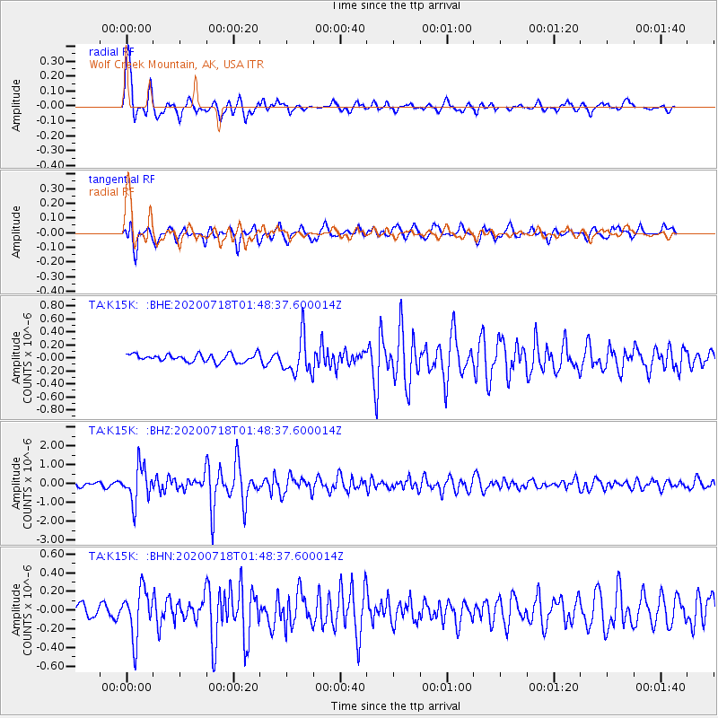
Signal To Noise
| Channel | StoN | STA | LTA |
| TA:K15K: :BHZ:20200718T01:48:37.600014Z | 11.785661 | 9.464164E-7 | 8.030236E-8 |
| TA:K15K: :BHN:20200718T01:48:37.600014Z | 4.1163425 | 2.589766E-7 | 6.2914246E-8 |
| TA:K15K: :BHE:20200718T01:48:37.600014Z | 4.872788 | 2.8882948E-7 | 5.9273972E-8 |
| Arrivals |
| Ps | 1.1 SECOND |
| PpPs | 4.6 SECOND |
| PsPs/PpSs | 5.8 SECOND |


