You are here: Home > Network List > XD94 - Tanzania BB Experiment Stations List
> Station PUGE XD.PUGE > Earthquake Result Viewer
PUGE XD.PUGE - Earthquake Result Viewer
| Earthquake location: |
Myanmar |
| Earthquake latitude/longitude: |
20.5/94.2 |
| Earthquake time(UTC): |
1994/05/29 (149) 14:11:51 GMT |
| Earthquake Depth: |
42 km |
| Earthquake Magnitude: |
6.2 MB, 6.2 MS, 5.9 UNKNOWN, 6.5 MW |
| Earthquake Catalog/Contributor: |
WHDF/NEIC |
|
| Network: |
XD Tanzania BB Experiment |
| Station: |
PUGE XD.PUGE |
| Lat/Lon: |
4.71 S/33.18 E |
| Elevation: |
1350 m |
|
| Distance: |
64.9 deg |
| Az: |
254.283 deg |
| Baz: |
64.847 deg |
| Ray Param: |
0.05857066 |
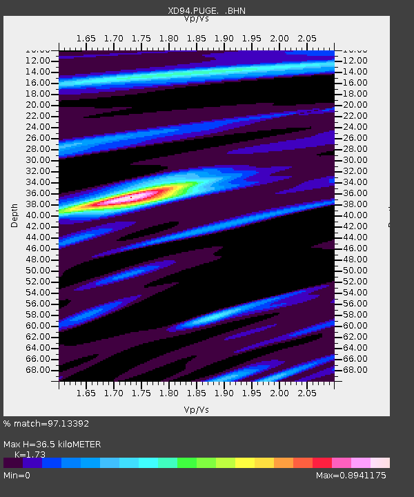
| Estimated Moho Depth: |
36.5 km |
| Estimated Crust Vp/Vs: |
1.73 |
| Assumed Crust Vp: |
6.459 km/s |
| Estimated Crust Vs: |
3.734 km/s |
| Estimated Crust Poisson's Ratio: |
0.25 |
|
| Radial Match: |
97.13392 % |
| Radial Bump: |
319 |
| Transverse Match: |
89.85167 % |
| Transverse Bump: |
400 |
| SOD ConfigId: |
16938 |
| Insert Time: |
2010-03-08 22:54:17.947 +0000 |
| GWidth: |
2.5 |
| Max Bumps: |
400 |
| Tol: |
0.001 |
|

Signal To Noise
| Channel | StoN | STA | LTA |
| XD:PUGE: :BHN:19940529T14:21:55.736011Z | 4.2108865 | 383.20123 | 91.0025 |
| XD:PUGE: :BHE:19940529T14:21:55.736011Z | 8.562761 | 760.5353 | 88.818924 |
| XD:PUGE: :BHZ:19940529T14:21:55.736011Z | 18.3991 | 2255.7637 | 122.60185 |
| Arrivals |
| Ps | 4.3 SECOND |
| PpPs | 15 SECOND |
| PsPs/PpSs | 19 SECOND |


