You are here: Home > Network List > US - United States National Seismic Network Stations List
> Station HLID Hailey, Idaho, USA > Earthquake Result Viewer
HLID Hailey, Idaho, USA - Earthquake Result Viewer
*The percent match for this event was below the threshold and hence no stack was calculated.
| Earthquake location: |
Solomon Islands |
| Earthquake latitude/longitude: |
-10.4/161.4 |
| Earthquake time(UTC): |
2020/07/18 (200) 01:37:14 GMT |
| Earthquake Depth: |
42 km |
| Earthquake Magnitude: |
5.9 Mww |
| Earthquake Catalog/Contributor: |
NEIC PDE/us |
|
| Network: |
US United States National Seismic Network |
| Station: |
HLID Hailey, Idaho, USA |
| Lat/Lon: |
43.56 N/114.41 W |
| Elevation: |
1772 m |
|
| Distance: |
92.9 deg |
| Az: |
46.395 deg |
| Baz: |
258.524 deg |
| Ray Param: |
$rayparam |
*The percent match for this event was below the threshold and hence was not used in the summary stack. |
|
| Radial Match: |
76.00939 % |
| Radial Bump: |
400 |
| Transverse Match: |
67.36199 % |
| Transverse Bump: |
400 |
| SOD ConfigId: |
21709731 |
| Insert Time: |
2020-08-01 01:58:01.163 +0000 |
| GWidth: |
2.5 |
| Max Bumps: |
400 |
| Tol: |
0.001 |
|
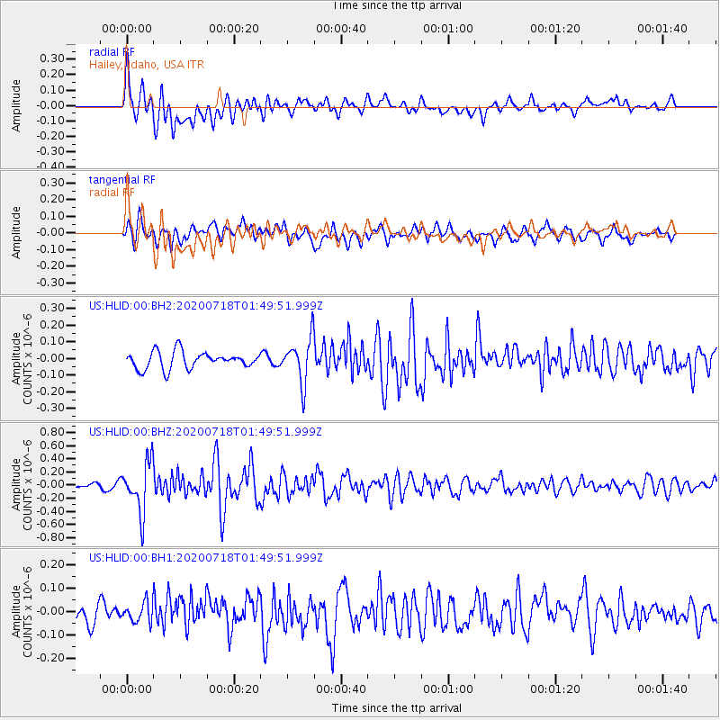
Signal To Noise
| Channel | StoN | STA | LTA |
| US:HLID:00:BHZ:20200718T01:49:51.999Z | 5.5126386 | 3.8299694E-7 | 6.947616E-8 |
| US:HLID:00:BH1:20200718T01:49:51.999Z | 0.71815646 | 4.1340567E-8 | 5.7564847E-8 |
| US:HLID:00:BH2:20200718T01:49:51.999Z | 2.694135 | 1.3691329E-7 | 5.0819015E-8 |
| Arrivals |
| Ps | |
| PpPs | |
| PsPs/PpSs | |


