You are here: Home > Network List > AV - Alaska Volcano Observatory Stations List
> Station AKBB Akutan Broiad Bright, Akutan Volcano, Alaska > Earthquake Result Viewer
AKBB Akutan Broiad Bright, Akutan Volcano, Alaska - Earthquake Result Viewer
| Earthquake location: |
Samoa Islands Region |
| Earthquake latitude/longitude: |
-15.3/-172.6 |
| Earthquake time(UTC): |
2020/07/18 (200) 15:32:35 GMT |
| Earthquake Depth: |
10 km |
| Earthquake Magnitude: |
6.2 Mww |
| Earthquake Catalog/Contributor: |
NEIC PDE/us |
|
| Network: |
AV Alaska Volcano Observatory |
| Station: |
AKBB Akutan Broiad Bright, Akutan Volcano, Alaska |
| Lat/Lon: |
54.10 N/165.93 W |
| Elevation: |
310 m |
|
| Distance: |
69.3 deg |
| Az: |
4.221 deg |
| Baz: |
186.927 deg |
| Ray Param: |
0.05572057 |
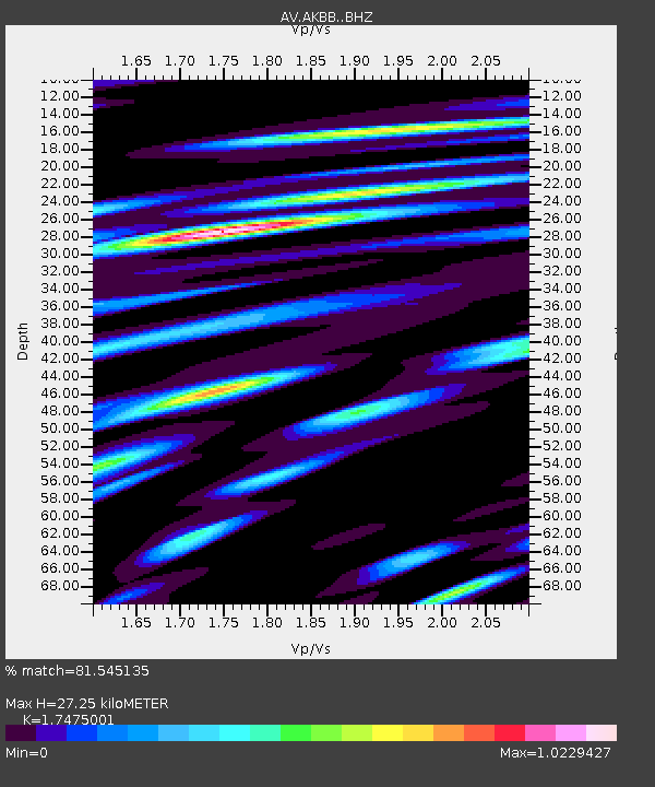
| Estimated Moho Depth: |
27.25 km |
| Estimated Crust Vp/Vs: |
1.75 |
| Assumed Crust Vp: |
5.989 km/s |
| Estimated Crust Vs: |
3.427 km/s |
| Estimated Crust Poisson's Ratio: |
0.26 |
|
| Radial Match: |
81.545135 % |
| Radial Bump: |
400 |
| Transverse Match: |
58.714985 % |
| Transverse Bump: |
400 |
| SOD ConfigId: |
21709731 |
| Insert Time: |
2020-08-01 15:35:35.753 +0000 |
| GWidth: |
2.5 |
| Max Bumps: |
400 |
| Tol: |
0.001 |
|

Signal To Noise
| Channel | StoN | STA | LTA |
| AV:AKBB: :BHZ:20200718T15:43:12.098989Z | 3.6285326 | 3.5146806E-7 | 9.686231E-8 |
| AV:AKBB: :BHN:20200718T15:43:12.098989Z | 0.9117765 | 1.15663404E-7 | 1.26855E-7 |
| AV:AKBB: :BHE:20200718T15:43:12.098989Z | 1.3380773 | 2.0356406E-7 | 1.5213176E-7 |
| Arrivals |
| Ps | 3.5 SECOND |
| PpPs | 12 SECOND |
| PsPs/PpSs | 16 SECOND |


