You are here: Home > Network List > AV - Alaska Volcano Observatory Stations List
> Station SSBA Shishaldin Broadband A, Shishldin Volcano, Alaska > Earthquake Result Viewer
SSBA Shishaldin Broadband A, Shishldin Volcano, Alaska - Earthquake Result Viewer
| Earthquake location: |
Samoa Islands Region |
| Earthquake latitude/longitude: |
-15.3/-172.6 |
| Earthquake time(UTC): |
2020/07/18 (200) 15:32:35 GMT |
| Earthquake Depth: |
10 km |
| Earthquake Magnitude: |
6.2 Mww |
| Earthquake Catalog/Contributor: |
NEIC PDE/us |
|
| Network: |
AV Alaska Volcano Observatory |
| Station: |
SSBA Shishaldin Broadband A, Shishldin Volcano, Alaska |
| Lat/Lon: |
54.77 N/164.12 W |
| Elevation: |
766 m |
|
| Distance: |
70.1 deg |
| Az: |
5.239 deg |
| Baz: |
188.748 deg |
| Ray Param: |
0.055192735 |
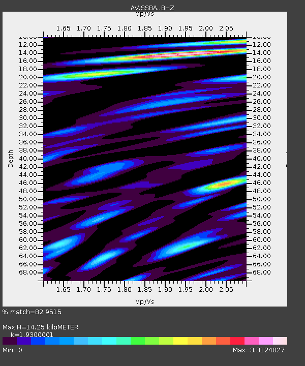
| Estimated Moho Depth: |
14.25 km |
| Estimated Crust Vp/Vs: |
1.93 |
| Assumed Crust Vp: |
5.989 km/s |
| Estimated Crust Vs: |
3.103 km/s |
| Estimated Crust Poisson's Ratio: |
0.32 |
|
| Radial Match: |
82.9515 % |
| Radial Bump: |
400 |
| Transverse Match: |
82.586945 % |
| Transverse Bump: |
400 |
| SOD ConfigId: |
21709731 |
| Insert Time: |
2020-08-01 15:36:27.426 +0000 |
| GWidth: |
2.5 |
| Max Bumps: |
400 |
| Tol: |
0.001 |
|

Signal To Noise
| Channel | StoN | STA | LTA |
| AV:SSBA: :BHZ:20200718T15:43:17.080007Z | 4.5203524 | 3.665176E-7 | 8.1081645E-8 |
| AV:SSBA: :BHN:20200718T15:43:17.080007Z | 0.82142836 | 1.1604905E-7 | 1.4127714E-7 |
| AV:SSBA: :BHE:20200718T15:43:17.080007Z | 0.5013081 | 6.068458E-8 | 1.2105247E-7 |
| Arrivals |
| Ps | 2.3 SECOND |
| PpPs | 6.8 SECOND |
| PsPs/PpSs | 9.0 SECOND |


